Siberian wildfires


On 29 July the European Space Agency (ESA) reported that hundreds of wildfires have broken out in Siberia, some of which can be seen in this image captured from space the previous day.
It is understood that almost three million hectares of land are estimated to have been affected, according to Russia’s Federal Forestry Agency.
This Copernicus Sentinel-3 image shows a number of fires, producing plumes of smoke. The smoke has carried air pollution into the Kemerovo, Tomsk, Novosibirsk, and Altai regions.
Furthermore, it is reported that an unprecedented amount of wildfires have been raging in regions of the Arctic, including Greenland and Alaska in the US. They have been caused by record-breaking high temperatures and lightning, fuelled by strong winds.
Neither UK nor EU ready for no deal

A new 128 page report issued by the Confederation of British Industry (CBI) on 28 July put forward 200 recommendations to help accelerate no deal preparations for the UK, the EU and companies. These points are based on a comprehensive study of existing plans laid out by the UK government, the European Commission, member states and firms.
Of particular interest to the shipping community will be pages 31, Movements, and 39, Haulage.
With the likelihood of no deal increasing, the CBI has backed up government efforts to help prepare for a no deal exit by publishing practical steps the UK, the EU and businesses can take to reduce the worst effects.
EDRS is a new, independent European satellite system

A second satellite to join the constellation that forms the European Data Relay System (EDRS) has finished fuelling and is days away from launch. This was reported by the European Space Agency (ESA) on 27 July.
It is understood that EDRS uses innovative laser technology to dramatically cut the time needed for Earth observation satellites to deliver information to the ground. The system enables observations of the Earth almost live, accelerating responses to emergency situations and spurring the development of new services and products, thereby creating jobs and prosperity, it is claimed.
INC 2019 Call for Papers
The International Navigation Conference of the Royal Institute of Navigation, is one of the premier forums for the presentation of research and advances in navigation.
INC2019, the fifth in this annual series, brings together industry, academia, and policy makers from around the world.
The deadline for submitting abstracts has been extended and is now 9 August.
European high temperatures

An extreme heatwave hit Europe once again in week commencing 21 July, following extreme weather in June. High temperatures were expected to peak on 25 July, reaching as high as 39-40°C, (102.2-104°F) with The Netherlands, Belgium and Germany recording their highest ever temperatures. Paris reached a sweltering 41°C (105.8°F), breaking its previous record in 1947.
The illustration here, an animation of two images, shows the land surface temperature from today July, compared to data recorded during the previous heatwave on 26 June 2019.
ICAO in Africa

Lower: Secretary General Dr Fang Liu with Uganda’s Minister of Works and Transport, Ms Monica Azuba Ntege, during a media scrum outside the opening ceremonies of ICAO’s 6th AFI Aviation Week meetings in Kampala.
Photo: www.icao.int ©
Opening the 6th ICAO Africa (AFI1) Aviation Week in Kampala in mid-May ICAO Secretary General Dr Fang Liu stressed how ongoing aviation safety, security, and capacity improvements all across Africa are maximizing air transport’s role as a catalyst for socio-economic development in the region.
Her remarks were delivered in the presence of Uganda’s Minister of Works and Transport, Ms Monica Azuba Ntege, and many governmental and diplomatic dignitaries including members of the ICAO Council.
ICAO Secretary General highlights future aviation challenges

In mid-June ICAO Secretary General Dr Fang Liu underscored a range of civil aviation priorities relating to economic growth and innovation as she introduced and took part in a high-level panel discussion on the future of air transport at the ICAO Conférence de Montréal.
Conducted under the auspices of the International Economic Forum of the Americas, the Montréal event featured wide-ranging government and industry VIP participation and covered a series of key issues relating to international finance, development, trade, and other policy topics of global relevance.
Dstl acquires first Satellite Ground Control Station for MOD Space Research and Development
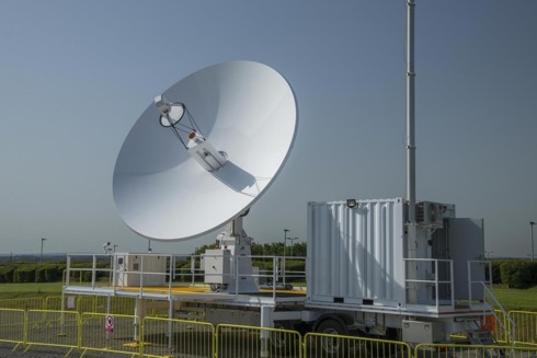
In the UK the Defence Science and Technology Laboratory (Dstl) reported on 18 July that it had acquired its first satellite ground control station to support future space research activities for the Ministry of Defence (MOD).
Based at Portsdown West, Hampshire, the ground station will use its 6.3m diameter antenna to direct satellites in both low-Earth and geosynchronous orbits, and will form a core part of the Dstl Space Science & Technology (S&T) programme.
IMO Maritime Safety Committee 101 outcomes

The 101st session of the IMO Maritime Safety Committee (MSC 101) was held at IMO HQ from 5-14 June.
Through the kind offices of the IMO media service we are able to bring you a briefing on a representative selection of the transactions that took place at the gathering. A number of these will be of interest to Members of IAIN.
2020 Israel Navigation Workshop and Exhibition
INWE20, the Israel Navigation Workshop and Exhibition, is a biennial event organized and sponsored by the Israel Association for Automatic Control (IAAC). Following the huge success of previous events, the 2020 edition has been scheduled for 27 January 2020 at the Daniel Hotel in Herzliya.
INWE20 will be a one-day event dedicated to technical talks in navigation systems ranging from fundamental research, to applications, to field test results.
Topics of interest include: navigation, positioning and timekeeping in all their variations; sensors, systems, optimal integration of multiple sensors, and novel or emerging technologies in the field of navigation.
In parallel with the talks the organisers will host a technical exhibit in which navigation equipment manufacturers and system suppliers will have the opportunity to show their current products and most recent technical innovations.
The Earth from Space – Japan’s Mount Fuji
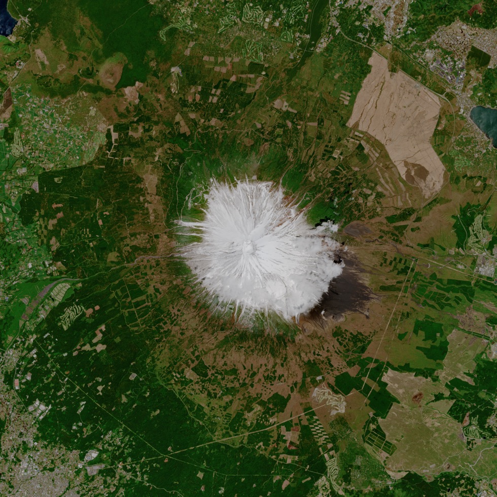
At the end of week commencing 7 July the European Space Agency (ESA) published the photograph shown here taken on a Copernicus Sentinel-2 mission over Mount Fuji, Japan’s highest mountain standing at 3776 metres. In this Spring image, the mountain can be seen coated in pure white snow.
This snow-capped mountain is often shrouded in cloud and fog, but the image was captured on a clear day, by the Copernicus Sentinel-2A satellite flying at a height of 800 km.
Mount Fuji is a symbol of Japan, and a popular tourist destination. Around 300,000 people climb the mountain every year – and in the image shown here several hiking trails can be seen leading to the base of the mountain.
US ties record for number of high tide flooding days in 2018
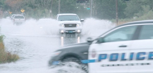
The US National Oceanic and Atmospheric Administration (NOAA) reported on 10 July that coastal communities across the US continued to see increased high tide flooding last year, forcing residents and visitors to deal with flooded shorelines, streets and basements. This is a trend that is expected to continue this year. Elevated water levels affected coastal economies, tourism and crucial infrastructure like septic systems and storm-water systems, according to the new NOAA document.
High tide flooding, often referred to as ‘nuisance’ or ‘sunny day’ flooding, is increasingly common due to years of relative sea level increases. It no longer takes a strong storm or a hurricane to cause flooding in many coastal areas.
The Journal of the US Institute of Navigation announces new journal impact factor growth
![]()
It was announced from ION’s HQ in Manassas, Virginia, on 2 July that the Institute of Navigation (ION) is once again pleased to announce the continued growth of NAVIGATION, The Journal of The Institute of Navigation, reflected in the latest Journal Impact Factor (JIF) report.
It is understood that the JIF of an academic journal is a measurement tool used to calculate the yearly average number of citations to recent articles published in a journal and is an indication of the relative importance of the journal within its field.
NAVIGATION’s Journal Impact Factor has now increased to 1.629, representing a 290% four-year increase.
Investigation finds unintended risks with ECDIS navigation
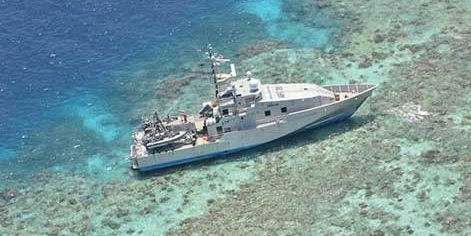
On 27 June the Australian Transport Safety Bureau (ATSB) issued the report of its investigation of the grounding of the Australian Border Force Cutter (ABFC) Roebuck Bay on Henry Reef, Queensland, on 30 September 2017. This document has revealed underlying safety issues with the effectiveness of ECDIS type-specific training, ECDIS software updates and the use of a single point feature to represent relatively large physical features on electronic navigational charts.
Roebuck Bay‘s electronic chart display and information system (ECDIS) identified the reef as a danger to the planned route, however, the crew did not identify the danger either visually or by using ECDIS. The vessel continued on the amended route and grounded on Henry Reef just after midnight. There were no reported injuries or oil pollution, but the vessel sustained substantial damage.
Trinity House celebrates World Marine Aids to Navigation Day 2019
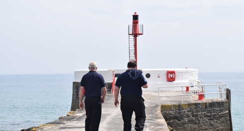
On 1 July 2019 Trinity House joined lighthouse and marine aids to navigation authorities around the world to mark the first ever World Marine Aids to Navigation Day, established to celebrate and promote the role of marine aids to navigation (AtoNs) and highlight the importance of safety at sea.
As a focal point for highlighting the importance of aids to navigation as a service for all mariners, Trinity House has chosen to emphasise its statutory duty as an auditor and inspector of local aids to navigation, rather than its more well-known duty as a provider of general aids to navigation such as lighthouses, lightvessels and buoys.
Local aids to navigation are owned and operated by Local Lighthouse Authorities rather than Trinity House, but the powers and duties granted to Trinity House require it to audit and inspect over 11,000 local AtoNs.
Trinity House to decommission Royal Sovereign Lighthouse
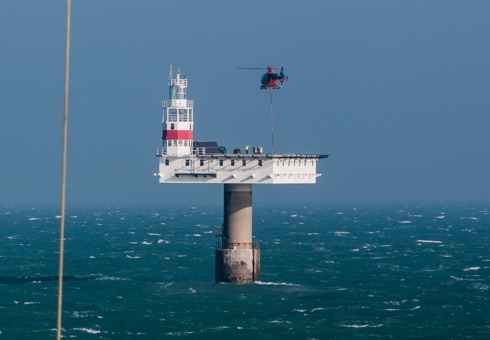
Trinity House London has begun preparatory work on a project to decommission Royal Sovereign Lighthouse in the English Channel. It is the intention that the now-deteriorating lighthouse will be completely removed clear to the seabed. This has necessitated that Beachy Head Lighthouse be upgraded to ensure the safety of the mariners in those waters. Trinity House aims to commence work in 2020.
Royal Sovereign Lighthouse was built in 1971 with a design life of 50 years. Having monitored the fabric of the lighthouse over the last decade and observing the expected signs of deterioration, Trinity House concluded that the ongoing safety of the mariner requires that the structure be fully decommissioned.
Royal Sovereign Lighthouse has provided nearly 50 years of reliable service as an aid to navigation, one of over 600 that Trinity House operates for the benefit and safety of the mariner.
ENC 2020 – Call for papers
The DGON, our member in the Federal Republic, the German Institute of Navigation, invites delegates to the beautiful city of Dresden.
On behalf of the Scientific Committee of the European Satellite Navigation Conference ENC 2020 the German Institute of Navigation (DGON) extends a welcome to ENC 2020 in Dresden
ENC 2020 will take place from 11-14 May 2020, at the MARITIM Hotel & Internationales Congress Center Dresden, Germany.
Call for papers
DGON invites potential delegates to submit their outstanding and valuable original research papers and to participate in the technical exhibition during the conference. The period for Draft Paper Submission is now open with closure on 1 November 2019.
IALA announces World Marine Aids to Navigation Day 2019

Events are being organized through the world and reports indicate that events will be held in Vanuatu, Japan, Argentina, Australia, Spain and Denmark.
The theme: Successful Voyages, Sustainable Planet serves to encompass the suggestions proposed by Members of IALA and accommodates all aspects of each of IALA’s Technical Committee. The theme reinforces the mission of IALA in the maritime arena for worldwide harmonisation of aids to navigation standards, the facilitation of the safety and efficiency of navigation and protection of the environment.
Desert greenery
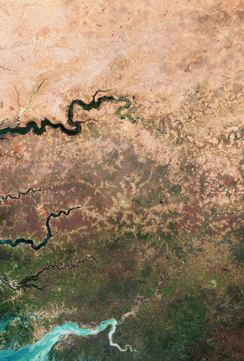
On 17 June ESA marked the 25th anniversary of World Day to Combat Desertification and Drought. Under its theme: Let’s grow the future together, the initiative celebrates the 25 years of progress made in sustainable land management.
One ambitious project – the Great Green Wall – aims to improve life in Africa’s desert regions by planting a belt of trees across the entire width of the continent. Once completed, the wall will be the largest living structure on the planet stretching across 20 countries – from Senegal in the west to Djibouti in the east. By 2030, the initiative aims to have restored 100 million hectares of degraded land, sequestered 250 million tonnes of carbon and created 10 million green jobs.
Captured by the Copernicus Sentinel-2 mission, the image (processed by the European Space Agency-ESA) is of the edge of the dry desert in west Africa contrasted with vegetated land. Signs of land degradation can be seen as brighter “islands” around villages and to a lesser extent along roads and rivers showing bare soil and degraded vegetation.
ESA informs us the image they kindly have distributed shows parts of three African countries: Senegal, The Gambia and Guinea-Bissau.
Marines land in Baltic exercise BALTOPS 2019
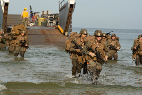
Maritime forces from 18 nations are currently taking part in the 47th annual multinational Exercise Baltic Operations (BALTOPS) in the Baltic Sea, running to 21 June. BALTOPS is the premier annual maritime-focused exercise in the Baltic region and one of the largest exercises in northern Europe, enhancing flexibility and interoperability among allied and partner nations.
Vice-Admiral Andrew Lewis, commander of the US 2nd Fleet, is leading the exercise on behalf of US Naval Forces Europe. In an interview he commented: ‘No one nation can face today’s challenges alone, we are much stronger together. Our partner and NATO alliances must continue to strengthen our deterrence and defence efforts and adapt through improving readiness and responsiveness.’
RAF Typhoons scramble to intercept Russian fighters – The Baltic Air Policing Mission
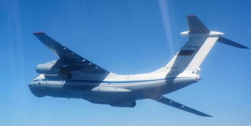
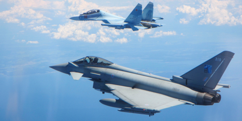
vRoyal Air Force (RAF) Typhoon fighter jets based at Ämari Air Base in Estonia were scrambled twice over the weekend (14-15 June) to intercept Russian fighter aircraft. Working in partnership with the Estonian authorities, this was a routine NATO airspace policing mission for the Typhoon detachment providing continued reassurance in the region.
This weekend’s activity indicates that the RAF have made eight intercepts of Russian aircraft since taking over the Baltic Air Policing mission on 3 May 2019.
New Chief Executive and Accounting Officer UKHO
At the end of May the UK Hydrographic Office (UKHO) reported that Rear- Admiral Tim Lowe had been appointed to the office of Chief Executive and Accounting Officer.
Admiral Lowe joined the UKHO as National Hydrographer and Deputy Chief Executive in 2015. In January 2019, he was made Acting Chief Executive, leading the UKHO’s transformation to become a modern marine geospatial information agency and hydrographic office. This included overseeing the opening of the UKHO’s award-winning office and championing key projects that have helped government, academia and the wider marine community make the best use of our oceans in safer, more secure and more sustainable ways.
Crew alertness avoids potential taxiing collision
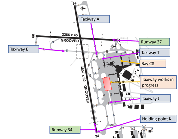
The Australian Transport Safety Bureau (ATSB) has reminded flight crews to remain alert and vigilant during taxiing, following an incident where a high workload situation probably led to an air traffic controller forgetting conflicting instructions had been issued.
During the 30 April 2018 incident, an Airbus A321 airliner was taxiing to the gate after landing at Melbourne Airport when the captain had to brake heavily to avoid a possible collision with a taxiing Boeing 737-800. Both aircraft had been given clearance by the surface movement controller in the control tower to proceed through the same taxiway intersection.
The Navigation Flashlight

From our Austrian member institute, the Österreichischer Verein für Navigation, we have received word of the latest issue of their regular publication, The Navigation Flashlight. It is published three times a year, currently in its nineteenth year of publication and it is in German.
Inmarsat and Hyundai Global Service agreement
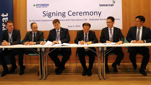
It was reported on 5 June that Inmarsat has signed a business cooperation agreement that allows Hyundai Global Service (HGS) to offer shipowners and managers a digital total care route to maritime digitalisation. HGS was established in 2016 by parent group Hyundai Heavy Industries as a digital transformation service provider to optimise ship operation and performance.
The unique agreement paves the way for a cooperation that will include the use of Fleet Xpress Dedicated Bandwidth Services by HGS to support its digital services for shipowners plus recognition of HGS as a Certified Application Partner (CAP) within Inmarsat’s digital ecosystem.