Changes to UK aviation security

Restrictions have been lifted on carrying large phones, laptops and tablets in the cabin on all UK-bound flights from the following airports in Turkey and Tunisia: Antalya, Bodrum, Istanbul Sabiha Gökçen and Izmir in Turkey; Tunis-Carthage International in Tunisia.
Passengers on flights where restrictions have been lifted will now be able to take large phones, laptops, tablets and accessories into the cabin with them. Normal cabin baggage restrictions will continue to apply.
Restrictions have also been lifted on a number of individual airlines operating from other airports. The vast majority of carriers operating out of Turkish airports are no longer subject to these restrictions. However, passengers should contact their airlines for advice about whether their flights are affected.
EUROCONTROL celebrates Bosnia and Herzegovina Civil Aviation Directorate at 20
At Banja Luka, Bosnia & Herzegovina, on 12 September Frank Brenner, Director General of EUROCONTROL, joined distinguished guests from European Air Traffic Management (ATM) to celebrate 20 years of the Directorate of Civil Aviation of Bosnia and Herzegovina (BHDCA). Brenner noted that in that time, Bosnia and Herzegovina had joined EUROCONTROL to become its 32nd member in 2004, playing a key role in European ATM within an organisation that now counts on 41 Member States as well as two Comprehensive Agreement States in the shape of Israel and Morocco.
Looking back on a highly successful partnership Brenner congratulated BHDCA for its tireless work in developing a regulatory and safety framework, and for its achievement in creating FABCE, a Functional Airspace Block Central Europe, aimed at jointly improving performance, which has seen the successful introduction of Free Route Airspace above flight level 310 (31,000ft).
ION ITM PTTI 2018

Readers are invited to submit abstracts online for the co-located ION ITM/PTTI 2018 conference that will take place from 29 January to 1 February, 2018 at the Hyatt Regency Reston, Reston, Virginia. The deadline for abstracts submission is 10 October, 2017.
ITM is the ION’s winter meeting with peer-reviewed technical papers related to positioning, navigation and timing and includes the ION Fellows and Annual Awards presentations. PTTI is the annual technical conference designed to disseminate and coordinate PTTI information at the user level; review present and future PTTI requirements; inform government and industry engineers, technicians and managers of precise time and frequency technology and its problems; and provide an opportunity for an active exchange of new technology associated with PTTI.
The Maritime Cloud becomes Maritime Connectivity Platform (MCP)

From Efficiensea2 has come news that the team behind the Maritime Cloud has decided to change the name of the communication framework. Maritime Connectivity Platform, MCP, has been chosen to provide clarity and support e-Navigation going from testbed to real life implementation.
The reason for the change is twofold explained Thomas Christensen: ‘MCP is at a level of maturity where we are ready to take it from our project spheres into operational mode. However, before taking that step we felt a strong need to clarify exactly what is being offered and what is being offered is a connectivity platform – not a storage cloud.’
Despite the new name, the ambition of MCP remains the same. The three partners aim to provide the maritime world with a communication framework that connects all maritime actors through the use of secure identities and trustworthy services.
(US) Institute of Navigation requests GNSS software defined radio (SDR) metadata standard

It was announced from the US Institute of Navigation‘s HQ in Manassas, Virginia, on 15 September that its GNSS Software Defined Radio Metadata Standard working group is seeking public comment on the standard up until 31 December, 2017.
There has been a proliferation of software defined radio (SDR) data collection systems and processing platforms designed for GNSS receiver applications or those that support GNSS bands. Post-processing has been a cumbersome and error-prone process because of the datasets of various formats, the subtleties of which are often lost in translation.
This GNSS SDR Metadata Standard defines parameters and schema (configuration) to express the contents of SDR sample data files and is designed to promote the interoperability of GNSS SDR data collection systems and processors. The metadata files are human readable and in XML format.
Comments are being accepted through to 32 December 2017 and may be made here.
Functional definitions for the ship’s stay in port
![]()
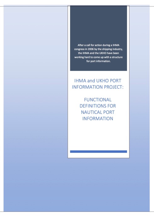
The International Harbour Masters’ Association (IHMA) is delighted to have participated in the development of functional definitions for port information describing the ship’s stay in port. Accurate and reliable port information will enhance the safety, efficiency and sustainability of ports and shipping across the world and benefit local, national and international economies.
This initiative’s priority is to improve communications between ships and ports using clear and authoritative definitions for the various terms used in daily operations. The definitions have been sourced from existing standards within the shipping industry. Only when no applicable definition could be found was a new one introduced and published via the glossary of the UKHO’s Mariners
Handbook (NP100). These definitions have been collated in an intermediate document and will be incorporated in the next version of the Mariners Handbook (NP100) to be published in August 2018. The Port of Rotterdam will begin using these definitions in 2017.
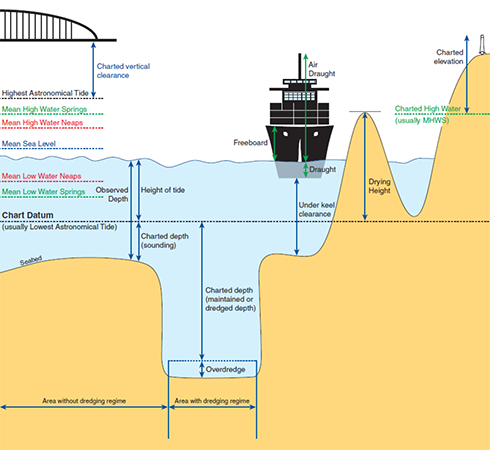
IHMA’s President, Capt. Kevin Richardson: ‘Harbour Masters recognise the huge value of agreeing and promulgating definitions that will make the ship’s stay in port safer and more efficient. We applaud the efforts of all organisations that have worked co-operatively on this important project which will have long-term value for ports around the world.’
Autonomous ships and the human element
As vessels become more and more autonomous consideration has to be given to the human element of future vessel operations, according to David Patraiko (illustrated), Director of Projects at The Nautical Institute.
Speaking on 11 September at the Autonomous, robotics and loT – exploring the potential and human impact conference organised by WISTA-UK (Women in Shipping and Trading Association) as part of London International Shipping Week, he said the human element in developments could not be ignored.
Pointing out that the existence of autonomous vessels is a reality with hundreds working today, Patraiko said they will be increasingly interacting with manned vessels. The NI’s work was of importance in ensuring relationships between the autonomous vessels and humans.
US Navy leads international effort to deploy buoys into the Arctic Ocean
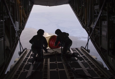
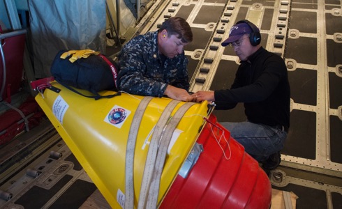
On 12 September the Office of the Oceanographer of the Navy and Office of Naval Research and US National Ice Center (USNIC) Public Affairs reported that with the Danish Joint Arctic Command, Environmental and Climate Change Canada and University of Washington deployed buoys into the Arctic Ocean during a joint mission. This joint mission was conducted to collect weather and oceanographic data to enhance forecasting and environmental models thereby reducing operational risk for assets in the Arctic.
In the words of Commander Ruth Lane, USNIC CO: ‘Polar lows are like hurricanes of the north and the data collected from these buoys will help us with numerical weather prediction, which will help to keep our and our partner forces safe. For example, when Hurricane Irma was approaching the Caribbean Islands, once the hurricane was within the range of NOAA’s Hurricane Hunter aircraft they flew out and dropped buoys through the hurricane. The surge of observations returned improved the track and intensity models. Forecast accuracy improves tremendously from the surge of local observations. Our goal with these Arctic buoys is a similar return on investment.’
Communication is key during an evacuation

US Navy Region Southeast Public Affairs reported from Jacksonville, Florida, on 9 September that many Navy personnel have evacuated to safe havens in advance of Hurricane Irma. At the same time the USN issued the image here.
A GOES satellite image taken on 8 September at 0945 EST shows Hurricane Irma, centre, in the Caribbean Sea, Hurricane Jose, right, in the Atlantic Ocean, and Hurricane Katia in the Gulf of Mexico. Hurricane Irma is a Category 4 hurricane with sustained winds of 155 mph and is approximately 500 miles southeast of Miami, moving west-northwest at 16 mph. Hurricane warnings were issued for South Florida, as the storm was expected to make landfall in Florida Saturday/Sunday.
RFA Mounts Bay delivers vital aid to Caribbean islands


On 8 September the (UK) Ministry of Defence reported that RFA Mounts Bay had delivered six tonnes of emergency aid to Anguilla, the British Overseas Territory devastated by Hurricane Irma, and was due to steam to the British Virgin Islands to provide further support within hours.
The naval auxiliary has been deployed in the Caribbean since July in preparation for the hurricane season, ready to provide support at a moment’s notice. Tasked by the Royal Navy, she was the UK’s first military response to the Caribbean. The ship carries a specialist disaster relief team – drawn from the Royal Engineers and Royal Logistics Corps (see troops illustrated) – as well as heavy plant for lifting and shifting and emergency kit and shelters (illustrated) provided by the Department for International Development. Also on board are the Royal Navy’s Mobile Aviation Support Force – aviation specialists, meteorological advisors and flight deck crews.
US Coast Guard and Hurricane Harvey

In a report from Portsmouth, Virginia, over the weekend 2/3 September it was learnt that US Coast Guard Atlantic Area personnel stationed in the Hampton Roads, Virginia, area continue to respond to the impacts of Hurricane Harvey. Local Coast Guard units providing support include the Fifth Coast Guard District, Force Readiness Command, Maritime Security Response Team, USCG Communications Command, Incident Management Assistance Team and members assigned to Base Portsmouth and the Portsmouth Federal Building.

A primary responsibility for Atlantic Area Command is to mobilize people and assets as well as provide command oversight. More than 250 Coast Guard members are actively participating in a response effort here in the Tidewater Area, and an additional 70 locally-sourced surge staff are scheduled to join the effort. More than 50 active duty and reserve personnel from the Tidewater Area are deployed to the affected areas in Texas and Louisiana. The Coast Guard expects this response to continue for an extended period, and to rotate personnel as necessary for clean up and port assessments. The search and rescue portion of the response is slowly winding down, with more than 10,600 lives saved so far.
Hurricane Harvey relief
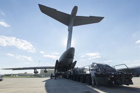
In the US Air Mobility Command (AMC) directed allocation of its airlift, aeromedical evacuation and contingency response assets to Federal Emergency Management Agency (FEMA) Hurricane Harvey relief efforts, as requested by US Northern Command (USNORTHCOM) on 30 August.
AMC C-17, C-130, C-5 and KC-10 aircraft from continental US AMC wings, elements of the 621st Contingency Response Wing at Joint Base McGuire-Dix-Lakehurst and various support personnel are deploying to affected areas of Texas to support ongoing FEMA- and USNORTHCOM-led efforts to provide relief to residents affected by the recent storm.
The US anti-missile missiles
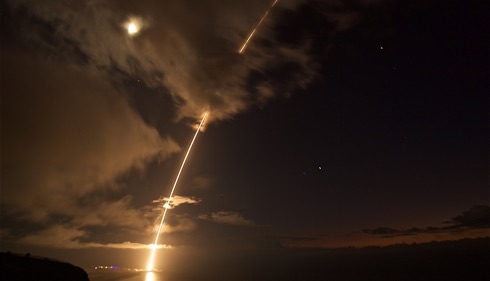
On 29 August it was reported that a medium-range ballistic missile target was launched from the Pacific Missile Range Facility in Kauai, Hawaii, during Flight Test Standard Missile-27, Event 2. The target was successfully intercepted by SM-6 missiles fired from the guided missile destroyer USS John Paul Jones (DDG 53).
Historical note: USS John Paul Jones is the fifth US warship to bear this name and honours the Father of the American Navy. Born in Scotland, Commodore John Paul Jones earned the undying respect and admiration of his countrymen by his extraordinary courage, tactical genius and audacity during the American War for Independence. John Paul Jones is best remembered for his heroic defeat of the British 50-gun frigate Serapis on 23 September 1779.
European Project tests new SAR tools
 A screenshot taken during the simulation – © EfficienSea2
Through sharing of data between vessels, new tools developed to enable more digital communication can make Search and Rescue operations both faster and better.
When navigating a ship through the less busy routes of the world, for example in Arctic waters, the ability to share data could take on increased significance in coming years. By using a new service developed with funding from the Nordic Council of Ministers and supported by the EU EfficienSea2 project, seafarers will be able to automatically exchange and coordinate vessel positions and search patterns while conducting SAR operations. The free service, available for all ships sailing through Arctic waters, only requires a functional internet connection and a log-in to the map-based platform ArcticWeb. It has just been successfully tested at simulations in Gothenburg by Chalmers University of Technology and the Swedish Maritime Administration.
Africa and ME aviation security

A high-level Ministerial Conference on Aviation Security held in Sharm El Sheikh, Egypt, during week commencing 20 August endorsed a new Africa and Middle East Aviation Security Roadmap to align future programmes and targets with ICAO’s new Global Aviation Security Plan (GASeP). This was reported from ICAO in Montreal at the week’s end.
In his address to the 27 attending Ministers and 35 Directors General of Civil Aviation, representing some 45 African and Middle Eastern Member States, ICAO Council President Dr Olumuyiwa Benard Aliu stressed that ICAO’s new Global Aviation Security Plan sets out key priorities where ICAO, States, and others should now focus their urgent attention, resources and efforts, as well as corresponding actions at the global, national and local levels.
RAF Typhoons hand over duties to Canada
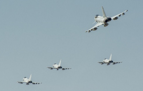
On 28 August four Royal Air Force Typhoon FGR4 fighter aircraft departed Romania ending the UK’s five-month leadership of NATO’s enhanced air policing mission in the country. Since April the Typhoons – from 3(F) Squadron, RAF Coningsby – had spent alternate weeks on high-readiness standby to defend NATO’s airspace over the Black Sea, augmenting the Romanian Air Force’s existing air defence capability. The Royal Canadian Air Force is now preparing to assume responsibility for the NATO mission, while two of the RAF’s Typhoons proceed to Estonia to join NATO training with the British Army.
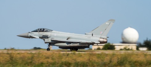
More than 300 regular and reserve RAF personnel from 16 RAF units – supported by Royal Engineers – were involved in the mission. Typhoons launched once in response to Russian air activity over the Black Sea and flew more than 280 sorties to support NATO training with Romanian, Hungarian and Bulgarian armed forces. Towards the end of 135 EAW’s tour of duty, eight of its personnel were awarded the Romanian Air Force’s highest peacetime honour for their work in the country.
Hurricane Harvey
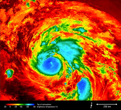
The Copernicus Sentinel-3A satellite saw the temperature at the top of Hurricane Harvey on 25 August at 0406 GMT as the storm approached the US state of Texas. The brightness temperature of the clouds at the top of the storm, some 12-15 km above the ocean, range from about -80°C near the eye of the storm to about 20°C at the edges.
Hurricanes are one of the forces of nature that can be tracked only by satellites, providing up-to-date imagery so that authorities know when to take precautionary measures.
USS John S McCain collides with merchant ship
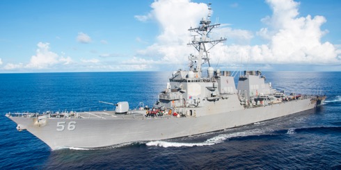 Official US Navy file photo of the Arleigh Burke-class guided-missile destroyer USS John S. McCain (DDG 56) – photo: USN ©
The guided-missile destroyer USS John S McCain (DDG 56) has arrived at Changi Naval Base following a collision with the merchant vessel Alnic MC while underway east of the Straits of Malacca and Singapore on 21 August. The collision was reported at 0624 Japan Standard Time. Significant damage to the hull resulted in flooding to nearby compartments, including crew berthing, machinery, and communications rooms. Damage control efforts by the crew halted further flooding.
There are currently ten Sailors missing and five injured. Four of the injured were medically evacuated by a Singapore Armed Forces helicopter to a hospital in Singapore for non-life threatening injuries. The fifth injured Sailor does not require further medical attention.
Search and rescue efforts continue in coordination with local authorities.
News updates here.
Sites to watch #4
These documents are issued by the UK Maritime and Coastguard Agency (MCA) and are a series of informative notices addressed to the Shipping Community including Owners, Managers, Masters and Agents.
A collection of active Marine Guidance Notes dating from April 2000 is
available here.
A collection of active MINs dating from May 2004 is available here.
MSNs from February 1963 onward are available here.
A collection of M-notices (MGNs and MSNs) relevant to the transport of dangerous goods by sea is available from March 1999 here.
Legislation relevant to Merchant Shipping Notices can be found here.
The Northern Sea Route
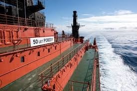
According to a report issued by the Chamber of Shipping of British Columbia, Canada, in its news round-up of 19 August a new speed record for reaching the North Pole has been set by Russia’s nuclear icebreaker 50 Let Pobedy, which made the passage from Murmansk to the North Pole in just 79 hours. It was reported that during the transit, the vessel hosted a conference dedicated to Arctic issues with a key topic being the economic worth of developing yearround navigation on the Northern Sea Route.
Carmanah closes purchase of Vega Industries Limited

Early in August it was announced from Victoria BC, Canada, that Carmanah Technologies Corporation had closed its previously announced transaction to acquire New Zealand-based Vega Industries Limited. The purchase price is NZD $12.0 million (USD $9.0 million) subject to certain adjustments and escrow holdbacks, it is understood.
This acquisition brings together Sabik Marine, Carmanah, Ekta, and Vega to create a global leader in the marine aids to navigation market. Integration plans, with a specific focus on providing marine aids to navigation customers comprehensive single-source solutions, are expected to be implemented over the coming months.
HMS Queen Elizabeth arrives at home port

Britain’s future flagship HMS Queen Elizabeth sailed into her home port of Portsmouth for the first time on 16 August. Greeted by thousands of people lining the Portsmouth seafront, the 65,000-tonnes displacement carrier was met with the warmest of welcomes as she arrived in her home port on the morning. Sailors lined the flight deck of the largest warship ever built for the Royal Navy as she passed Portsmouth’s Round Tower. HMS Queen Elizabeth was also greeted with a flypast from the Fleet Air Arm, including Wildcat and Merlin helicopters and Hawk jets.
ESA’s Large Space Simulator

An external view of Europe’s largest vacuum chamber, the Large Space Simulator, which subjects entire satellites to space-like conditions ahead of launch. This 15 metre-high and 10 metre-diameter chamber is cavernous enough to accommodate an upended double decker bus, it has been reported.
Satellites are lowered down through a top hatch. Once the top and side hatches are sealed, high-performance pumps create a vacuum a billion times lower than standard sea level atmosphere, held for weeks at a time during test runs. A 121-segment mirror array reflects simulated sunlight into the chamber, at the same time as the internal walls are pumped full of -190°C liquid nitrogen, together recreating the extreme thermal conditions prevailing in orbit.
Japan Coast Guard Global Summit

The Nippon Foundation and the Japan Coast Guard held a press conference on 18 July to announce the Coast Guard Global Summit, a forum of senior maritime safety officials to be held in Tokyo on 14 September, with a total of 40 countries, territories, and institutions expected to participate. This summit is also expected to issue a joint statement calling for cooperation that transcends existing bilateral and regional frameworks.
At the press conference, Admiral Satoshi Nakajima, commandant of the Japan Coast Guard, referred to Prime Minister Shinzo Abe’s message delivered to the launch ceremony of the Umi-to-Nippon Project (The Ocean and Japan Project), held on Japan’s Marine Day public holiday (17 July). In his message, Prime Minister Abe stressed the importance of global-level cooperation among institutions on the front line of maritime safety issues, along with diplomacy, toward achieving free and safe seas.
Sweltering southern Europe – the ESA Sentinel mission

Southern Europe is in the grip of a relentless heatwave, fuelling wildfires and water shortages. Information from the Copernicus Sentinel-3A satellite has been used to map the sweltering heat across the region.

The main objective of the Sentinel-3 mission is to measure sea surface topography, sea and land surface temperature, and ocean and land surface colour with high accuracy and reliability to support ocean forecasting systems, environmental monitoring and climate monitoring. The mission is jointly operated by ESA and EUMETSAT to deliver operational ocean and land observation services.