Amazon wildfires
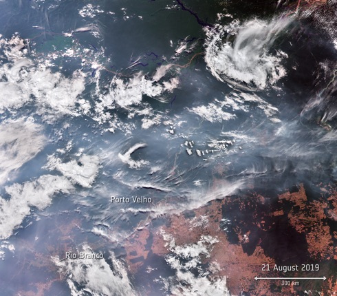
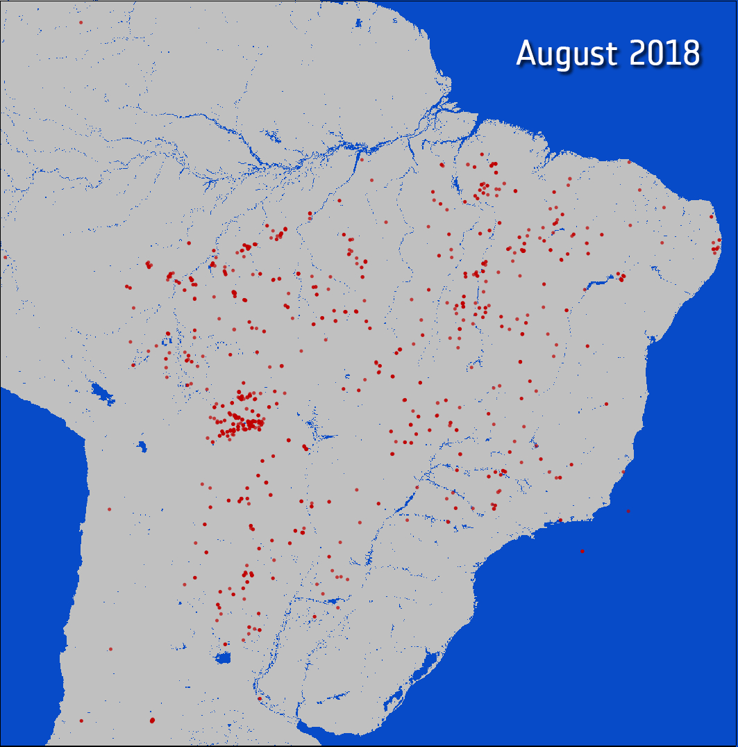
In recent weeks thousands of fires have broken out in the Amazon rainforest. Satellite data show that there are almost four times as many fires this year compared to the same period last year (2018). Apart from Brazil, parts of Peru, Bolivia, Paraguay and Argentina have also been affected. This was reported in a communiqué from the European Space Agency (ESA) on 27 August.
While forest fires normally occur in Brazil’s dry season, which runs from July to October, the unprecedented increase is reported to come from both legal and illegal deforestation which allows land to be used for agricultural purposes, rising global temperatures are also thought to be making the region more susceptible to fire.
Sites to watch #11
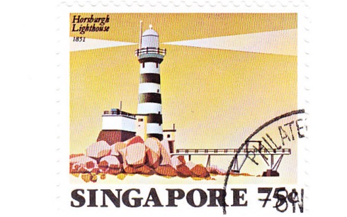
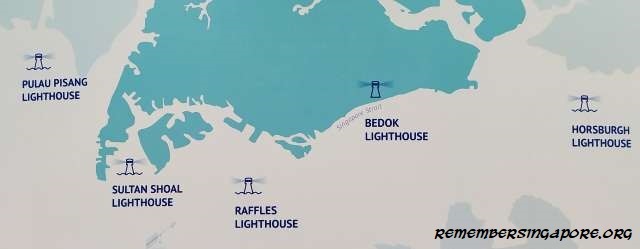
Lighthouses, typically located on islands and shoals near the approaches to ports and harbours, provide visual aids to navigational for seafarers. In addition, they also serve as the warning of hazards such as rocks and reefs.
We are informed by Remember Singapore that currently five of Singapore’s lighthouses are managed by the Maritime and Port Authority of Singapore (MPA).
Hamburg Pilots’ Choir annual concert 2019
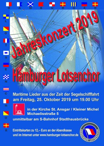
According to Captain Dieter Wulf, the Hamburg Pilots’ Choir will perform their Annual concert in St Ansgar’s Church / Kleiner Michel in Michaelisstrasse 5 Hamburg (S-Bahnhof Stadhausbrucke) on Friday 25 October 2019 at 1900.
Sites to watch #10

ITU is the United Nations specialized agency for information and communication technologies – ICTs.
There is an important article on ITU’s news site introducing a revolution in railway communication by Dirk Schattschneider, Senior Spectrum Manager, Deutsche Bahn AG.
Today’s constantly increasing traffic and threat of climate change, are forcing more and more governments to look for alternative transport. Shifting traffic from the road to the railways is one option for consideration as rail systems are by far the most environmentally-friendly means of transport.
NTSB findings on the collision between USS John S McCain and Alnic MC
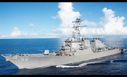
On 12 August the (US) National Transportation Safety Board announced that the 21 August 2017 collision between the USS John S McCain and the tanker Alnic MC was caused by insufficient training, inadequate bridge operating procedures and a lack of operational oversight.
Ten sailors aboard John S McCain died in the accident and 48 were injured when the ships collided in the Middle Channel passage of the Singapore Strait Traffic Separation Scheme. There were no injuries to the crew of Alnic MC. Property damage resulting from the collision exceeded $1.2 million. There was no report of pollution associated with the accident.
Dana Schulze new Director of NTSB Office of Aviation Safety

At the end of July the (US) National Transportation Safety Board announced a change in leadership in the agency’s Office of Aviation Safety.
Dana Schulze (pictured) assumed the duties of Director, Office of Aviation Safety, effective from 22 July.
Schulze has served as the Deputy Director of the Office of Aviation Safety since 2012 and has concurrently served as the office’s acting director since November 2018. Schulze has been with the NTSB since 2002, has been a member of the Senior Executive Service since 2012 and earned a 2017 Distinguished Presidential Rank Award.
Maerospace acquires rights to long range radar system
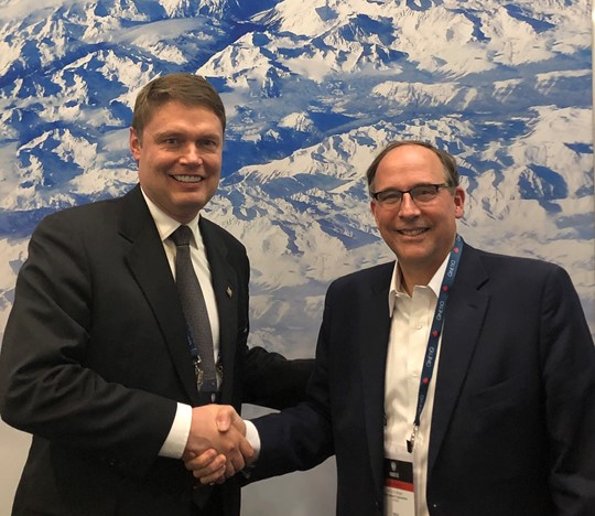
It was announced from Waterloo, Ontario, on 1 August that Maerospace Corporation, a global supplier of real-time, predictive analytics to the maritime market, had signed a global license agreement with Raytheon Canada Limited (RCL) to support the Defence Research and Development Canada (DRDC), the Department of National Defence and Canadian Armed Forces’ science and technology organization.
Maerospace will assume responsibility for the maintenance, design, engineering, manufacturing and international promotion, sales and deployment of the third generation High Frequency Surface Wave Radar (HFSWR) systems. This Canadian system is one of the few operationally deployed HFSWR land-based radars capable of 200-mile, persistent coverage of a country’s Exclusive Economic Zone (EEZ).
Threat assessment for commercial shipping Mediterranean Sea
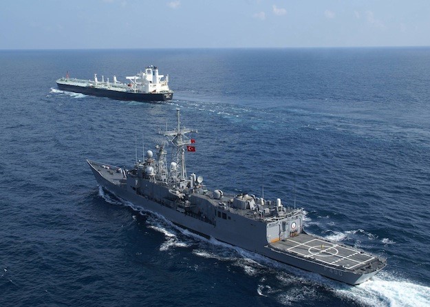
The Mediterranean Sea is one of the world’s busiest bodies of water; from the Strait of Gibraltar to the Levant coast, it covers approximately 2,500 miles and occupies an area of nearly 970,000 square miles.
While the region offers safe transit to commercial traffic and entry to the Middle East and beyond via the Suez Canal, regional instability in certain areas such as Libya and Syria have the potential to spill over into adjacent waters posing a possible threat to commercial traffic.
A recent report by NATO provides a general assessment on the threat posed to commercial shipping while transiting the Mediterranean in open waters.
RAF Typhoons scramble from UK and Estonia
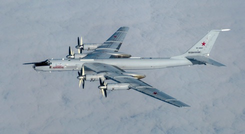
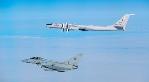
The RAF Typhoons deployed on NATO Baltic Air Policing in Estonia intercepted a Russian TU-95 ‘Bear’ Bomber, heading west close to Estonian airspace. The Typhoons then handed the escort over to Finnish and Swedish QRA aircraft, before being tasked to re-intercept to maintain the escort of the TU-95 as it transited close to NATO airspace. The ‘Bear’ had since been accompanied by two Russian SU-30 ‘Flanker’ fighters.
This is a routine NATO mission for the Typhoons which provides reassurance that the UK is here to work in partnership with Estonia.
Silver Spitfire leaves UK on worldwide flight

Two intrepid aviators – Matt Jones and Steve Brooks – left Goodwood Aerodrome on 5 August to attempt to fly a Silver Spitfire around the world, taking in some of the most famous landmarks on the planet from the Grand Canyon in the West to the snow-capped peak of Mount Fuji in the East.
This Spitfire is a UK treasure and represents an emblem of freedom across the globe. The Silver Spitfire expedition is expected to promote the Best of British worldwide showcasing the nation’s heritage in engineering excellence, and an aircraft that changed the course of history.
Sites to watch #9
![]()
The European Global Navigation Satellite Systems Agency (otherwise known
as the GSA) is the link between space technology and user needs.
The GSA’s mission is to ensure that users in Europe and around the world fully benefit from Europe’s satellite navigation programmes. To do this, the Agency is responsible for the operations and service provision for both EGNOS and Galileo.
You can subscribe to GSA’s newsletter here. There is an RSS feed available as well.
Sites to watch #8
Regarding failure of Galileo and the possibilities of alternative systems readers may wish to keep up to date with the website of the Resilient Navigation and Timing Foundation. The Foundation is a Corresponding Member of IAIN.
Siberian wildfires
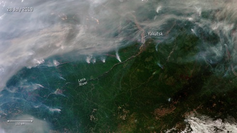

On 29 July the European Space Agency (ESA) reported that hundreds of wildfires have broken out in Siberia, some of which can be seen in this image captured from space the previous day.
It is understood that almost three million hectares of land are estimated to have been affected, according to Russia’s Federal Forestry Agency.
This Copernicus Sentinel-3 image shows a number of fires, producing plumes of smoke. The smoke has carried air pollution into the Kemerovo, Tomsk, Novosibirsk, and Altai regions.
Furthermore, it is reported that an unprecedented amount of wildfires have been raging in regions of the Arctic, including Greenland and Alaska in the US. They have been caused by record-breaking high temperatures and lightning, fuelled by strong winds.
Neither UK nor EU ready for no deal

A new 128 page report issued by the Confederation of British Industry (CBI) on 28 July put forward 200 recommendations to help accelerate no deal preparations for the UK, the EU and companies. These points are based on a comprehensive study of existing plans laid out by the UK government, the European Commission, member states and firms.
Of particular interest to the shipping community will be pages 31, Movements, and 39, Haulage.
With the likelihood of no deal increasing, the CBI has backed up government efforts to help prepare for a no deal exit by publishing practical steps the UK, the EU and businesses can take to reduce the worst effects.
EDRS is a new, independent European satellite system
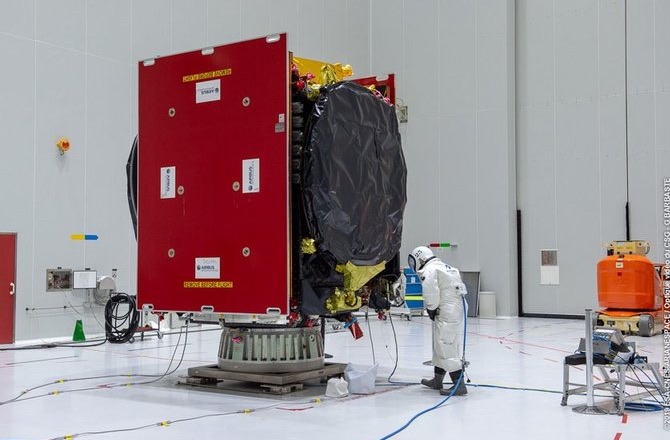
A second satellite to join the constellation that forms the European Data Relay System (EDRS) has finished fuelling and is days away from launch. This was reported by the European Space Agency (ESA) on 27 July.
It is understood that EDRS uses innovative laser technology to dramatically cut the time needed for Earth observation satellites to deliver information to the ground. The system enables observations of the Earth almost live, accelerating responses to emergency situations and spurring the development of new services and products, thereby creating jobs and prosperity, it is claimed.
INC 2019 Call for Papers
The International Navigation Conference of the Royal Institute of Navigation, is one of the premier forums for the presentation of research and advances in navigation.
INC2019, the fifth in this annual series, brings together industry, academia, and policy makers from around the world.
The deadline for submitting abstracts has been extended and is now 9 August.
European high temperatures

An extreme heatwave hit Europe once again in week commencing 21 July, following extreme weather in June. High temperatures were expected to peak on 25 July, reaching as high as 39-40°C, (102.2-104°F) with The Netherlands, Belgium and Germany recording their highest ever temperatures. Paris reached a sweltering 41°C (105.8°F), breaking its previous record in 1947.
The illustration here, an animation of two images, shows the land surface temperature from today July, compared to data recorded during the previous heatwave on 26 June 2019.
ICAO Secretary General highlights future aviation challenges

In mid-June ICAO Secretary General Dr Fang Liu underscored a range of civil aviation priorities relating to economic growth and innovation as she introduced and took part in a high-level panel discussion on the future of air transport at the ICAO Conférence de Montréal.
Conducted under the auspices of the International Economic Forum of the Americas, the Montréal event featured wide-ranging government and industry VIP participation and covered a series of key issues relating to international finance, development, trade, and other policy topics of global relevance.
ICAO in Africa

Lower: Secretary General Dr Fang Liu with Uganda’s Minister of Works and Transport, Ms Monica Azuba Ntege, during a media scrum outside the opening ceremonies of ICAO’s 6th AFI Aviation Week meetings in Kampala.
Photo: www.icao.int ©
Opening the 6th ICAO Africa (AFI1) Aviation Week in Kampala in mid-May ICAO Secretary General Dr Fang Liu stressed how ongoing aviation safety, security, and capacity improvements all across Africa are maximizing air transport’s role as a catalyst for socio-economic development in the region.
Her remarks were delivered in the presence of Uganda’s Minister of Works and Transport, Ms Monica Azuba Ntege, and many governmental and diplomatic dignitaries including members of the ICAO Council.
Dstl acquires first Satellite Ground Control Station for MOD Space Research and Development
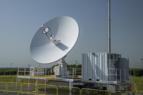
In the UK the Defence Science and Technology Laboratory (Dstl) reported on 18 July that it had acquired its first satellite ground control station to support future space research activities for the Ministry of Defence (MOD).
Based at Portsdown West, Hampshire, the ground station will use its 6.3m diameter antenna to direct satellites in both low-Earth and geosynchronous orbits, and will form a core part of the Dstl Space Science & Technology (S&T) programme.
IMO Maritime Safety Committee 101 outcomes

The 101st session of the IMO Maritime Safety Committee (MSC 101) was held at IMO HQ from 5-14 June.
Through the kind offices of the IMO media service we are able to bring you a briefing on a representative selection of the transactions that took place at the gathering. A number of these will be of interest to Members of IAIN.
2020 Israel Navigation Workshop and Exhibition

INWE20, the Israel Navigation Workshop and Exhibition, is a biennial event organized and sponsored by the Israel Association for Automatic Control (IAAC). Following the huge success of previous events, the 2020 edition has been scheduled for 27 January 2020 at the Daniel Hotel in Herzliya.
INWE20 will be a one-day event dedicated to technical talks in navigation systems ranging from fundamental research, to applications, to field test results.
Topics of interest include: navigation, positioning and timekeeping in all their variations; sensors, systems, optimal integration of multiple sensors, and novel or emerging technologies in the field of navigation.
In parallel with the talks the organisers will host a technical exhibit in which navigation equipment manufacturers and system suppliers will have the opportunity to show their current products and most recent technical innovations.
The Earth from Space – Japan’s Mount Fuji
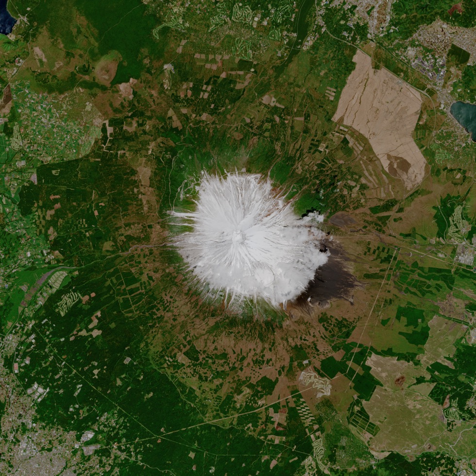
At the end of week commencing 7 July the European Space Agency (ESA) published the photograph shown here taken on a Copernicus Sentinel-2 mission over Mount Fuji, Japan’s highest mountain standing at 3776 metres. In this Spring image, the mountain can be seen coated in pure white snow.
This snow-capped mountain is often shrouded in cloud and fog, but the image was captured on a clear day, by the Copernicus Sentinel-2A satellite flying at a height of 800 km.
Mount Fuji is a symbol of Japan, and a popular tourist destination. Around 300,000 people climb the mountain every year – and in the image shown here several hiking trails can be seen leading to the base of the mountain.
US ties record for number of high tide flooding days in 2018
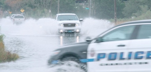
The US National Oceanic and Atmospheric Administration (NOAA) reported on 10 July that coastal communities across the US continued to see increased high tide flooding last year, forcing residents and visitors to deal with flooded shorelines, streets and basements. This is a trend that is expected to continue this year. Elevated water levels affected coastal economies, tourism and crucial infrastructure like septic systems and storm-water systems, according to the new NOAA document.
High tide flooding, often referred to as ‘nuisance’ or ‘sunny day’ flooding, is increasingly common due to years of relative sea level increases. It no longer takes a strong storm or a hurricane to cause flooding in many coastal areas.
The Journal of the US Institute of Navigation announces new journal impact factor growth
![]()
It was announced from ION’s HQ in Manassas, Virginia, on 2 July that the Institute of Navigation (ION) is once again pleased to announce the continued growth of NAVIGATION, The Journal of The Institute of Navigation, reflected in the latest Journal Impact Factor (JIF) report.
It is understood that the JIF of an academic journal is a measurement tool used to calculate the yearly average number of citations to recent articles published in a journal and is an indication of the relative importance of the journal within its field.
NAVIGATION’s Journal Impact Factor has now increased to 1.629, representing a 290% four-year increase.