GPS ground system anomaly

On 28 January the US Air Force announced from the 2nd Space Operations Squadron at the 50th Space Wing, Schriever Air Force Base, Colorado, that verified users were experiencing GPS timing issues.
Further investigation revealed an issue in the Global Positioning System ground software which only affected the time on legacy L-band signals. This change occurred when the oldest vehicle, SVN 23, was removed from the constellation.
While the core navigation systems were working normally, the coordinated universal time timing signal was off by 13 microseconds, which exceeded the design specifications. The issue was resolved at 0610 MST, however global users may have experienced GPS timing issues for several hours.
Innovation in maritime navigation – event

To be held 2 March 2016 at Trinity House, London, this event will explore the mix of technologies for future maritime navigation, and identify potential complements to GNSS.
The Knowledge Transfer Network (KTN), the Royal Institute of Navigation (RIN) and the General Lighthouse Authorities of Great Britain and Ireland (GLAs) are running an event exploring all technologies for robust, costeffective ship navigation over the next fifteen years.
More on the IAIN calendar and at the RIN.
ICAO post-COP21 views

Shortly before the end of 2015 ICAO reported from Montreal that the Secretary General of the International Civil Aviation Organization (ICAO), Dr. Fang Liu, had exchanged post-COP21 views and other developments with the European Commissioner for Mobility and Transport, Ms Violeta Bulc, (pictured) during a visit to Brussels.
Following discussions Commissioner Bulc held with ICAO Council President Dr Olumuyiwa Benard Aliu, she and Secretary General Liu exchanged further points on ICAO’s framework for its Environmental Protection activities and its planning leading up to the 39th ICAO triennial Assembly (A39).
ICAO will be seeking the support of its 191 Member States at A39 in September 2016 on the proposed design and 2020 implementation of a new market-based measure (MBM) for international aviation emissions.
Eurocontrol’s first overview of 2015

The unstable political situation within and at the borders of the NM area had a significant impact on flight efficiency and the general environment, necessitating longer routes to avoid dangerous zones. Even under these circumstances the actual trajectory targets have been met showing that the European airspace structure offers appropriate capabilities.
European aviation traffic just missed the all-time high of 2008. Capacity shortfalls, mainly in Cyprus and France, made it difficult to achieve network delay targets with industrial action adding to the complexity.
A limited number of air traffic control centres (ACCs) generated delays in summer, largely due to insufficient flexibility in sector availability. Other ACCs struggled to cope with traffic increases in those sectors affected by the shift in flows resulting from geo-political events – and higher route charges.
GNSS – Trust but verify
On 19 January 2016 the United States Coast Guard issued an alert (Safety Alert 01-16) reminding users that this past summer (2015), multiple outbound vessels from a non-US port suddenly lost GPS signal reception.
The net effect was various alarms and a loss of GPS input to the ship’s surface search radar, gyro units and Electronic Chart Display & Information System (ECDIS), resulting in no GPS data for position fixing, radar over ground speed inputs, gyro speed input and loss of collision avoidance capabilities on the radar display.
More on the subject with advice to mariners as to what they should do in
reporting disruption is to be found here.
Atomic clock with enhanced stability programme
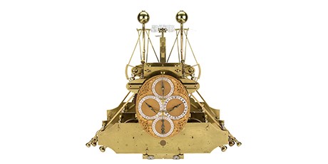
Proposers’ Day 1 February 2016 – News has been received from the US that the Defense Advanced Research Projects Agency (DARPA) is holding a Proposers’ Day on 1 February to inform potential contractors about the Atomic Clock with Enhanced Stability (ACES) programme.
ACES is a potential $50 million programme that seeks to develop battery powered atomic clocks that work to provide the military with synchronization and precision timing capabilities during navigation, communications, electronic warfare and reconnaissance missions in the event of a GPS shutdown.
IMO – a message from the Secretary General


Mr Kitack Lim was elected Secretary-General of the Organization by the 114th session of the IMO Council in June 2015 for a four-year period beginning 1 January 2016. The election was endorsed by IMO’s Assembly at its 29th session in November 2015. Kitack Lim (Republic of Korea) is the eighth elected Secretary-General of the International Maritime Organization.
We reproduce here by kind courtesy the new IMO Secretary-General’s message
Hidden histories of the information age
Hidden Histories of the Information Age is a series of short radio programmes available on BBC Radio 4.
Today’s 15-minute programme, the fifth out of five, tells the story of how GPS helped navigation in the first Gulf War (1990 – 1991).
This link will take you to the BBC to listen to it.
This link will take you to the series web page where you can find the other four programmes as well, and this link will allow you to download it.
The programme should be available for 28 days.
Industry pays tribute to Alert!
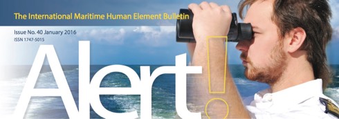
Just over twelve years ago The Nautical Institute launched its international human element bulletin, Alert! The first issue came out in October 2003, as seafarers were getting to grips with new technology and automation. It was becoming clear that more attention needed to be paid to human-centred design and human factors engineering as well as seafarer training.
Since 2003, there has been a transformation in the industry’s understanding of the human element in ship design, construction, management and operation. The journal Alert! has played its part in that sea change.
Former Lloyd’s Register CEO Richard Sadler noted: ‘Every article in every issue over the years has dealt with the fundamentals of the human factor and increased the awareness of every reader. I am sure we could find evidence that this publication has directly or indirectly saved lives and accidents.’
Alert! #40 is available here.
Enduring eye: the Antarctic legacy of Sir Ernest Shackleton and Frank Hurley

One of the greatest photographic records of human survival has gone on display in a remarkable new exhibition at the Royal Geographical Society (with IBG) in London. Running to 28 February 2016 this exhibition honours the achievements of Sir Ernest Shackleton and the men of the Endurance Expedition of 1914-1917. Newly digitised images reveal previously unseen details of the crew’s epic struggle for survival both before and after their ship was destroyed.
eLoran timing and data signals from the U.K.
News was received from Taviga (a new collaboration derived from Timing and Navigation) on 7 January that low frequency eLoran transmissions from Anthorn in Cumbria (UK) will continue despite the switch off of the legacy Loran-C transmissions by the French, Norwegian, Danish, and German transmitters. Signals from the Russian Loran-C equivalent – Chayka – are still available, it is understood.
All European Loran-C stations except Anthorn ceased at 1100 on 31 December 2015.
Taviga’s press release of 7 January 2016 is available here.
China Institute of Navigation – Change of Board of Directors
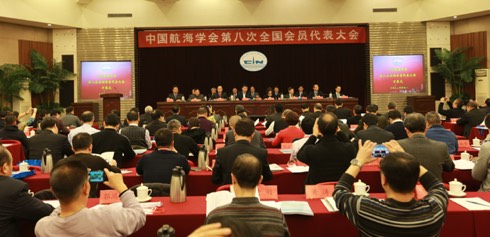
The 8th National Member Conference of the China Institute of Navigation (CIN) was held in Beijing on 12 December last.

The working report and financial report of the 7th Board of Directors were published at the Conference. The 8th Board of Directors was selected at the same time. President of Shanghai Maritime University, Professor HUANG Youfang, was selected as the chairman. Mr YU Shicheng, (Guangzhou Salvage Bureau, Ministry of Transportation), was selected as the Executive Vicechairman. Mr WANG Qun, (Rescue & Salvage Bureau, Ministry of Transportation), was selected as the Secretary General.

The international workshop on Tsunami Inundation Mapping (TIM)

On 25/26 November 2015 a training course was organised by the Hydrographic and Oceanographic Department of the Japan Coast Guard (JHOD). This was achieved with the assistance of the Intergovernmental Oceanographic Commission (IOC); the International Hydrographic Organization (IHO) and the Port and Airport Research Institute (PARI). The event was held in JHOD’s office in Tokyo.
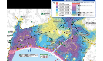
According to Japan Coast Guard this was the first time such a workshop had been held among Hydrographic Offices in the East Asia region. The objective of the workshop was to improve capacity of Hydrographic Offices mainly in the East Asia countries for development and utilization of the tsunami inundation map (illustrated). They then went on to discuss the way forward to realize this
understanding, through lectures given by researchers from Tohoku University, PARI, and others sharing experiences or challenges.
A New Year message
We wish a happy, successful and safe New Year to all our Members and readers.
Available here is the New Year message from Yasuo Arai of the Japan Institute of Navigation, President of IAIN.
A New Year message form Yasuo Arai, President of IAIN
During the past year, the evolution of remotely piloted or entirely autonomous vehicles has proceeded apace and, as we discovered during our Congress in October, there continues to be a huge amount of effort being expended in academia and other research fora in developing new, multi-sensor navigational techniques and, especially, ever more clever processing of GNSS signals in order to solve the growing demands for determining a vehicle’s very precise position but, it seems, comparatively little work on alternatives to GNSS.
Around the world, this year-end has been marked by extreme weather events, some of which have been ascribed to the effects of climate change and some to the El Niño phenomenon. What if there had also been an extreme space weather event – a solar coronal mass ejection towards Earth? How would all those autonomous, remotely piloted and, indeed, manned vehicles manage without GNSS? It is not just we navigators who need a back-up. What about financial markets, power grids and communications networks? At the end of 2015 France and Norway will cease funding the eLORAN infrastructure in their territory thereby denying its use as a back up to GNSS in NW Europe. At the same time the US Army and US Department of Transportation have recently expressed renewed interest in an alternative positioning, navigation and timing system and the Republic of Korea is vigorously pursuing the development of one. Furthermore, the United States Navy is reintroducing training in astro-navigation for its personnel as it recognizes that there is a need to have a fall back method of determining position in the event of GNSS denial for whatever reason.
Several of the presentations at Congress introduced yet more proposals for systems that purport to assist the human operators of traditional craft and particularly marine vessels. But, however sophisticated such systems are, they are generally disincentives to the operator to look out – still the primary method by which we humans generate local situational awareness. All types of manned, remotely piloted and autonomous vehicles need to ‘look out’ by means of one, or more, sensors in order to avoid conflict with other vehicles and specifically, if they are to be permitted to operate amongst manned vehicles, traffic such as airliners and marine craft, not to mention pedestrians!
It is to be hoped that 2016 will be the year when researchers, commerce and the regulators will focus on solving the twin challenges of identifying or developing: first, truly viable alternative navigation systems independent of space with seamless and responsive communication and/or data exchanges, fully able to function wherever required, including indoors, underground and underwater, and to provide the necessary GNSS back-up capability to provide Positioning, Navigation and Timing; and, secondly, multi-sensor suites that will enhance every vehicle’s capacity to be fully aware of its situation in relation to both its physical environment and other users of that environment.
We wish a happy, successful and safe New Year to all our Members and readers.
 Yasuo Arai,
(Japan Institute of Navigation)
President IAIN
ORBCOMM second mission completes OG2 constellation
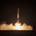
It was reported on 21 December by ORBCOMM Inc from Rochelle Park, New Jersey, that it had successfully launched eleven next generation OG2 satellites from Cape Canaveral Air Force Station, Florida at 2029 ET that day. These eleven satellites were successfully separated from the Falcon 9 launch vehicle into the proper insertion orbit.
After an initial health check, the satellites will undergo extensive In-Orbit Testing (IOT) to verify that all subsystems are properly functioning. The satellites are expected to be providing full commercial M2M messaging and
Automatic Identification System (AIS) services within the next 60 days.
Captain Alfred Norman Cockcroft †

CAPTAIN ALFRED NORMAN COCKCROFT, Extra Master, M.Phil., FRIN, FNI
21 March 1930 – 8 December 2015
Captain Cockcroft became a Member of the Royal Institute of Navigation (RIN) in 1963 and was awarded a Fellowship in 1976 (FRIN). He was awarded the Institute’s Bronze Medal, for the Journal of Navigation’s best paper, as well as the Gold Medal in 1982. In the period until the late 1990s within RIN he became Chairman of the Marine Traffic and Navigation Group, was a member of Council and of the Technical Committee, served as Vice-President and represented the Institute on the UK Safety of Navigation Committee. He also represented the International Association of Institutes of Navigation (IAIN) at the International Maritime Organization (IMO), was a Visiting Professor at the IMO World Maritime University and became an IMO consultant on ship routeing projects.
Norman Cockcroft had Parkinson’s disease in his later years and passed away at the age of 85 on 8 December 2015. His wife Janice, with whom he had two sons and two daughters, predeceased him by six weeks.
Bureau Veritas’ international pilotage certification to Port of Cork
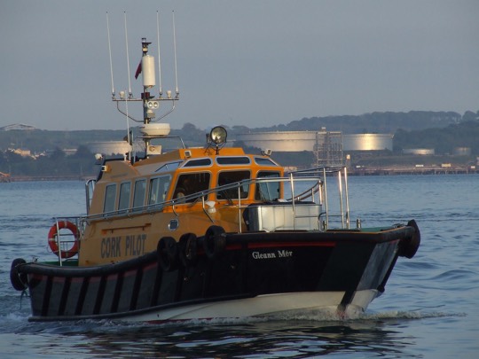
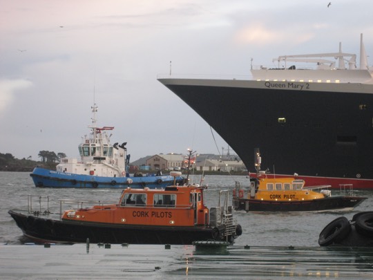
Classification society Bureau Veritas has issued its first certificate under the ISPO (International Standard for Maritime Pilot Organizations) standard of best practice for pilots and pilot organizations to the pilotage authority, the Port of Cork, Ireland.
The ISPO certification covers the pilotage services and Vessel Traffic Management System. It is an accessible industry specific standard, managed by a group of users, that improves safety and quality and provides transparency to ship owners and stakeholders on pilotage standards.
The ISPO certification for the Port of Cork covers twelve pilots who safely managed mixed marine traffic handling over 9 million tonnes of cargo and 56 cruise ship calls during 2015.
SeaRobotics will manufacture Lockheed Martin’s commercial deepwater AUV
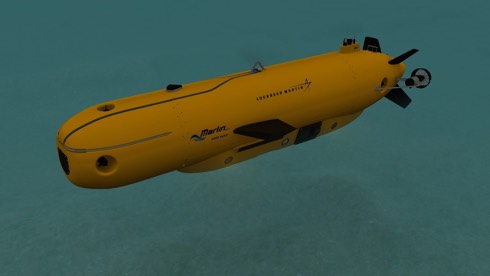
It was announced from Palm Beach, Florida, on 14 December that Lockheed Martin has selected SeaRobotics Corporation as the Original Equipment Manufacturer (OEM) for its Marlin® Mk3 Autonomous Underwater Vehicle (AUV) designed for survey and inspection applications in depths up to 4,000 metres.
Designed for deepwater applications such as pipeline inspection, deepwater survey, and life of field support services for oil and gas, the Marlin® Mk3’s modular, plug and play mission package architecture and dual AUV/Remote Operated Vehicle propulsion modes is a revolution in AUV technology that can perform a wide range of deepwater geophysical survey and structural integrity management inspection operations.
12th ISIS-MTE 2016 call for papers
A Call for Papers has been issued for the 12th International Symposium on Integrated Ship’s Information Systems (ISIS) & Maritime Traffic Engineering Conference organised by the German Institute of Navigation, Deutsche Gesellschaft für Ortung und Navigation e. V. (DGON), in co-operation with the Maritime University of Sczcecin, Poland.
Abstracts to be submitted by 15 April 2016.
Integrated Ship’s Information Systems (ISIS) are recognized to be the effective means to enhance safety and efficiency of maritime traffic systems. They are used, for example, in ships, in vessel traffic services as well at fleet service centres to analyse situations, improve awareness, support decision making and the management processes.
ISIS will be an excellent platform to present advanced approaches for Green
Navigation and Unmanned Ships as well as for further future concepts. More information here.
NTSB completes
documentation of sunken
cargo ship El Faro

It was announced in mid-November from Washington by the National Transportation Safety Board (NTSB) that video documentation of the cargo ship El Faro and the associated debris field has been completed but the vessel’s voyage data recorder has not been located.
Despite locating the ship on October 30 and locating the missing navigation bridge on November 11, after searching for five more days using CURV-21, a remotely operated vehicle, it was determined that the VDR could not be located. The search and video documentation efforts of El Faro were completed on 15 November. No further search missions are planned, it is understood.
Enhanced Loran trials discontinued
Trinity House, the General Lighthouse Authority for England, Wales and the Channel Islands, have given notice that from 1100 UTC on 31 December 2015, it will discontinue the Initial Operational Capability (IOC) prototype/trials of Enhanced LORAN (eLORAN) in the waters of the United Kingdom and Ireland.
Mariners have been advised that from 1100 UTC on 31 December 2015 all currently equipped eLORAN and LORAN-C receivers in northwest Europe will cease to function correctly and such receivers should be switched off until further notice.
IMO Council elections

The elections for the 40-member executive Council of the International Maritime Organization (IMO) for the next biennium (2016-2017) took place on 27 November 2015, as part of the regular biennial session of the IMO Assembly (29th session, 23 November-2 December 2015).
IMO Council elections

The elections for the 40-member executive Council of the International Maritime Organization (IMO) for the next biennium (2016-2017) took place on 27 November 2015, as part of the regular biennial session of the IMO Assembly (29th session, 23 November-2 December 2015).
First ICAO World Aviation Forum

The International Civil Aviation Organization (ICAO) convened the first-ever World Aviation Forum (IWAF) with the theme: Aviation Partnerships for Sustainable Development, from 23 to 25 November 2015 in Montréal. The IWAF was attended by over 800 participants representing ICAO Member States, international organizations, financial institutions and the industry sector.
IWAF participants came together to help maximize opportunities for enhancing global aviation. They strongly supported the Organization’s No Country Left Behind (NCLB) campaign to assist States in implementing ICAO Standards and Recommended Practices (SARPs).
