Hurricane Harvey relief
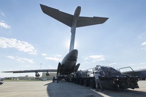
In the US Air Mobility Command (AMC) directed allocation of its airlift, aeromedical evacuation and contingency response assets to Federal Emergency Management Agency (FEMA) Hurricane Harvey relief efforts, as requested by US Northern Command (USNORTHCOM) on 30 August.
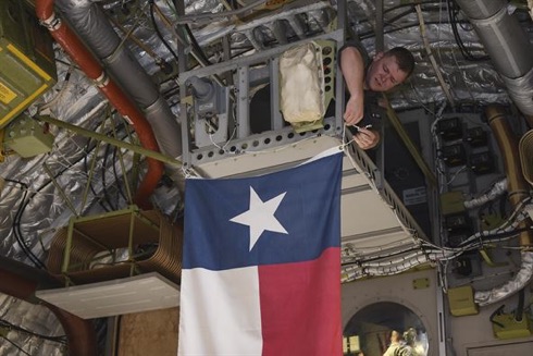
AMC C-17, C-130, C-5 and KC-10 aircraft from continental US AMC wings, elements of the 621st Contingency Response Wing at Joint Base McGuire-Dix-Lakehurst and various support personnel are deploying to affected areas of Texas to support ongoing FEMA- and USNORTHCOM-led efforts to provide relief to residents affected by the recent storm.
US Coast Guard and Hurricane Harvey

In a report from Portsmouth, Virginia, over the weekend 2/3 September it was learnt that US Coast Guard Atlantic Area personnel stationed in the Hampton Roads, Virginia, area continue to respond to the impacts of Hurricane Harvey. Local Coast Guard units providing support include the Fifth Coast Guard District, Force Readiness Command, Maritime Security Response Team, USCG Communications Command, Incident Management Assistance Team and members assigned to Base Portsmouth and the Portsmouth Federal Building.

A primary responsibility for Atlantic Area Command is to mobilize people and assets as well as provide command oversight. More than 250 Coast Guard members are actively participating in a response effort here in the Tidewater Area, and an additional 70 locally-sourced surge staff are scheduled to join the effort. More than 50 active duty and reserve personnel from the Tidewater Area are deployed to the affected areas in Texas and Louisiana. The Coast Guard expects this response to continue for an extended period, and to rotate personnel as necessary for clean up and port assessments. The search and rescue portion of the response is slowly winding down, with more than 10,600 lives saved so far.
The US anti-missile missiles
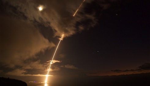
On 29 August it was reported that a medium-range ballistic missile target was launched from the Pacific Missile Range Facility in Kauai, Hawaii, during Flight Test Standard Missile-27, Event 2. The target was successfully intercepted by SM-6 missiles fired from the guided missile destroyer USS John Paul Jones (DDG 53).
Historical note: USS John Paul Jones is the fifth US warship to bear this name and honours the Father of the American Navy. Born in Scotland, Commodore John Paul Jones earned the undying respect and admiration of his countrymen by his extraordinary courage, tactical genius and audacity during the American War for Independence. John Paul Jones is best remembered for his heroic defeat of the British 50-gun frigate Serapis on 23 September 1779.
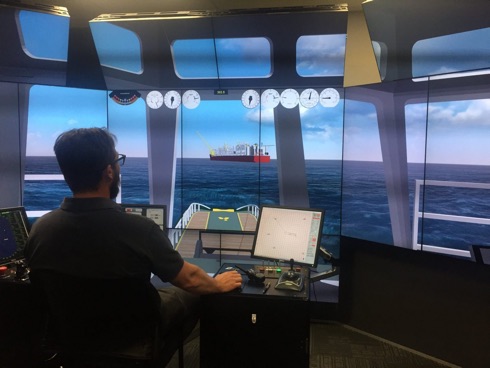
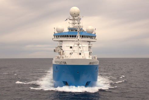
European Project tests new SAR tools
 A screenshot taken during the simulation – © EfficienSea2
Through sharing of data between vessels, new tools developed to enable more digital communication can make Search and Rescue operations both faster and better.
When navigating a ship through the less busy routes of the world, for example in Arctic waters, the ability to share data could take on increased significance in coming years. By using a new service developed with funding from the Nordic Council of Ministers and supported by the EU EfficienSea2 project, seafarers will be able to automatically exchange and coordinate vessel positions and search patterns while conducting SAR operations. The free service, available for all ships sailing through Arctic waters, only requires a functional internet connection and a log-in to the map-based platform ArcticWeb. It has just been successfully tested at simulations in Gothenburg by Chalmers University of Technology and the Swedish Maritime Administration.
Africa and ME aviation security

A high-level Ministerial Conference on Aviation Security held in Sharm El Sheikh, Egypt, during week commencing 20 August endorsed a new Africa and Middle East Aviation Security Roadmap to align future programmes and targets with ICAO’s new Global Aviation Security Plan (GASeP). This was reported from ICAO in Montreal at the week’s end.
In his address to the 27 attending Ministers and 35 Directors General of Civil Aviation, representing some 45 African and Middle Eastern Member States, ICAO Council President Dr Olumuyiwa Benard Aliu stressed that ICAO’s new Global Aviation Security Plan sets out key priorities where ICAO, States, and others should now focus their urgent attention, resources and efforts, as well as corresponding actions at the global, national and local levels.
RAF Typhoons hand over duties to Canada
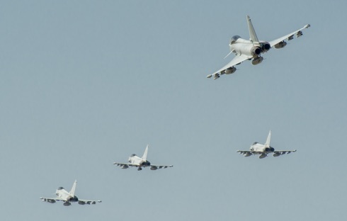
On 28 August four Royal Air Force Typhoon FGR4 fighter aircraft departed Romania ending the UK’s five-month leadership of NATO’s enhanced air policing mission in the country. Since April the Typhoons – from 3(F) Squadron, RAF Coningsby – had spent alternate weeks on high-readiness standby to defend NATO’s airspace over the Black Sea, augmenting the Romanian Air Force’s existing air defence capability. The Royal Canadian Air Force is now preparing to assume responsibility for the NATO mission, while two of the RAF’s Typhoons proceed to Estonia to join NATO training with the British Army.
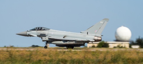
More than 300 regular and reserve RAF personnel from 16 RAF units – supported by Royal Engineers – were involved in the mission. Typhoons launched once in response to Russian air activity over the Black Sea and flew more than 280 sorties to support NATO training with Romanian, Hungarian and Bulgarian armed forces. Towards the end of 135 EAW’s tour of duty, eight of its personnel were awarded the Romanian Air Force’s highest peacetime honour for their work in the country.
Hurricane Harvey

The Copernicus Sentinel-3A satellite saw the temperature at the top of Hurricane Harvey on 25 August at 0406 GMT as the storm approached the US state of Texas. The brightness temperature of the clouds at the top of the storm, some 12-15 km above the ocean, range from about -80°C near the eye of the storm to about 20°C at the edges.
Hurricanes are one of the forces of nature that can be tracked only by satellites, providing up-to-date imagery so that authorities know when to take precautionary measures.
USS John S McCain collides with merchant ship
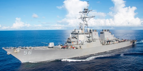 Official US Navy file photo of the Arleigh Burke-class guided-missile destroyer USS John S. McCain (DDG 56) – photo: USN ©
The guided-missile destroyer USS John S McCain (DDG 56) has arrived at Changi Naval Base following a collision with the merchant vessel Alnic MC while underway east of the Straits of Malacca and Singapore on 21 August. The collision was reported at 0624 Japan Standard Time. Significant damage to the hull resulted in flooding to nearby compartments, including crew berthing, machinery, and communications rooms. Damage control efforts by the crew halted further flooding.
There are currently ten Sailors missing and five injured. Four of the injured were medically evacuated by a Singapore Armed Forces helicopter to a hospital in Singapore for non-life threatening injuries. The fifth injured Sailor does not require further medical attention.
Search and rescue efforts continue in coordination with local authorities.
News updates here.
The Northern Sea Route
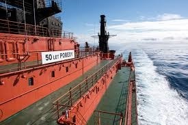
According to a report issued by the Chamber of Shipping of British Columbia, Canada, in its news round-up of 19 August a new speed record for reaching the North Pole has been set by Russia’s nuclear icebreaker 50 Let Pobedy, which made the passage from Murmansk to the North Pole in just 79 hours. It was reported that during the transit, the vessel hosted a conference dedicated to Arctic issues with a key topic being the economic worth of developing yearround navigation on the Northern Sea Route.
Sites to watch #4
These documents are issued by the UK Maritime and Coastguard Agency (MCA) and are a series of informative notices addressed to the Shipping Community including Owners, Managers, Masters and Agents.
A collection of active Marine Guidance Notes dating from April 2000 is
available here.
A collection of active MINs dating from May 2004 is available here.
MSNs from February 1963 onward are available here.
A collection of M-notices (MGNs and MSNs) relevant to the transport of dangerous goods by sea is available from March 1999 here.
Legislation relevant to Merchant Shipping Notices can be found here.
Carmanah closes purchase of Vega Industries Limited

Early in August it was announced from Victoria BC, Canada, that Carmanah Technologies Corporation had closed its previously announced transaction to acquire New Zealand-based Vega Industries Limited. The purchase price is NZD $12.0 million (USD $9.0 million) subject to certain adjustments and escrow holdbacks, it is understood.
This acquisition brings together Sabik Marine, Carmanah, Ekta, and Vega to create a global leader in the marine aids to navigation market. Integration plans, with a specific focus on providing marine aids to navigation customers comprehensive single-source solutions, are expected to be implemented over the coming months.
ESA’s Large Space Simulator
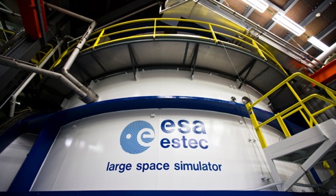
An external view of Europe’s largest vacuum chamber, the Large Space Simulator, which subjects entire satellites to space-like conditions ahead of launch. This 15 metre-high and 10 metre-diameter chamber is cavernous enough to accommodate an upended double decker bus, it has been reported.
Satellites are lowered down through a top hatch. Once the top and side hatches are sealed, high-performance pumps create a vacuum a billion times lower than standard sea level atmosphere, held for weeks at a time during test runs. A 121-segment mirror array reflects simulated sunlight into the chamber, at the same time as the internal walls are pumped full of -190°C liquid nitrogen, together recreating the extreme thermal conditions prevailing in orbit.
HMS Queen Elizabeth arrives at home port

Britain’s future flagship HMS Queen Elizabeth sailed into her home port of Portsmouth for the first time on 16 August. Greeted by thousands of people lining the Portsmouth seafront, the 65,000-tonnes displacement carrier was met with the warmest of welcomes as she arrived in her home port on the morning. Sailors lined the flight deck of the largest warship ever built for the Royal Navy as she passed Portsmouth’s Round Tower. HMS Queen Elizabeth was also greeted with a flypast from the Fleet Air Arm, including Wildcat and Merlin helicopters and Hawk jets.
Japan Coast Guard Global Summit

The Nippon Foundation and the Japan Coast Guard held a press conference on 18 July to announce the Coast Guard Global Summit, a forum of senior maritime safety officials to be held in Tokyo on 14 September, with a total of 40 countries, territories, and institutions expected to participate. This summit is also expected to issue a joint statement calling for cooperation that transcends existing bilateral and regional frameworks.
At the press conference, Admiral Satoshi Nakajima, commandant of the Japan Coast Guard, referred to Prime Minister Shinzo Abe’s message delivered to the launch ceremony of the Umi-to-Nippon Project (The Ocean and Japan Project), held on Japan’s Marine Day public holiday (17 July). In his message, Prime Minister Abe stressed the importance of global-level cooperation among institutions on the front line of maritime safety issues, along with diplomacy, toward achieving free and safe seas.
Sweltering southern Europe – the ESA Sentinel mission

Southern Europe is in the grip of a relentless heatwave, fuelling wildfires and water shortages. Information from the Copernicus Sentinel-3A satellite has been used to map the sweltering heat across the region.

The main objective of the Sentinel-3 mission is to measure sea surface topography, sea and land surface temperature, and ocean and land surface colour with high accuracy and reliability to support ocean forecasting systems, environmental monitoring and climate monitoring. The mission is jointly operated by ESA and EUMETSAT to deliver operational ocean and land observation services.
UK Space Agency seeks international partnerships

At the end of July it was announced by the UK Space Agency that it is working with research institutions, industry and non-profit organisations to develop strong international partnerships to help tackle economic, societal and environmental issues using satellite technology.
It is understood that the Agency will award funding through its International Partnership Programme (IPP), which is designed to partner UK space expertise with overseas governments and organisations. This is part of the Global Challenges Research Fund (GCRF), which aims to support cutting-edge research and innovation that addresses the challenges faced by developing countries.
Ten small and medium sized enterprises (SMEs) and research organisations have been given a total of £338,000 to use to establish partnerships in countries including Zambia, Ethiopia and Vietnam.
Vega liftoff
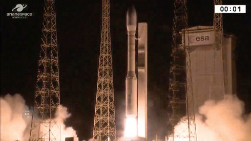
On the morning of 2 August Arianespace launched a Vega rocket carrying two Earth observation satellites for Italy, France and Israel encased in Vega’s lighter protective fairing.
Liftoff of Vega’s tenth mission from Europe’s Spaceport in Kourou, French Guiana came at 0158 GMT (0358 Central European Summer Time) or 2258 local time on a mission lasting 97 minutes to deliver Optsat-3000 and Venµs into their planned orbits. Optsat-3000 will provide Italy’s Ministry of Defence with global high resolution images. With a mass of 368 kg, it was the first to be released after about 42 minutes. The 264 kg Venµs was released 49 minutes later. Venµs (Vegetation and Environment monitoring on a New Micro Satellite) sponsored by France and Israel will study vegetation and the environment, and demonstrate a new electrical propulsion system.
Optsat-3000 has a design life of seven years and Venµs four and a half years.
ICAO President urges cooperation in airspace management for unmanned aircraft
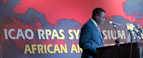
Opening the ICAO Remotely Piloted Aircraft Systems Symposium (RPAS) in Abuja on 18 July, ICAO Council President Dr Olumuyiwa Benard Aliu stressed the importance of a globally coherent regulatory framework for the management of unmanned air traffic. He remarked: ‘If you consider a company envisaging a global drone fleet to enhance its deliveries, the value of having a myriad of domestic national regulations aligned via globally harmonized international standards becomes clearly apparent.’
President Aliu also stressed the complexity of this task, notably in terms of the tremendous diversity of types and applications of Unmanned Aircraft Systems
(UAS), and the need to place safety first.
Aviation priorities for Brexit negotiations: The Air League’s view
Founded in 1909, The Air League’s mission is to enhance national understanding of the importance to the UK of aviation and aerospace. The Air League’s vision is to ensure continued recognition by leaders in the UK that a strong aviation and aerospace sector is essential to the economic prosperity and security of the UK.
At the end of July the League published a second briefing paper on Aviation and Brexit. This document seeks to contribute positively to the debate to help ensure the continued contribution the sector makes to the prosperity, employment, global connectivity, and economic development of the UK.
Working within an EU framework has helped the UK aerospace and air transport sectors to develop and prosper with a minimum of cross-border restrictions in Europe, operating to common standards, facilitating market access, free from customs and tariff restrictions.
Simulation makes perfect
At 488metres loa Shell’s Prelude FLNG facility was always going to represent a formidable challenge even for the skilled tug masters who were charged with towing the facility from the shipyard in the Republic of Korea where it was constructed, and delivering it to its final destination, a remote gas field 475 kilometres off the coast of Western Australia. This was reported by HR Wallingford, UK, on 1 August.
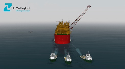
Practice makes perfect, and HR Wallingford, using its Australia Ship Simulation Centre in Fremantle created an accurate and detailed navigation simulation of Prelude for Shell, which was used to prepare the Tow Masters, Tug Masters and Pilots, allowing them to familiarise themselves with a realistic simulation of Prelude manoeuvres at sea. On 25 July Prelude arrived safely at its destination in the East Browse Basin.
SeaRobotics and autonomous hydrographic survey vehicles
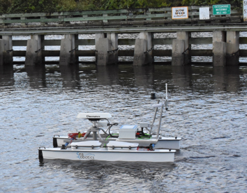
SeaRobotics Corporation (SeaRobotics) reported on 31 July that it had delivered two complete autonomous 2.5 metre unmanned surface vehicles (USVs) to a government hydrographic service. These USVs, built by SeaRobotics, are complete hydrographic systems providing multibeam echo sounders (MBES), support sensors, a cast winch, deployment carts, and road trailers.
This contract reinforces the commitment government and commercial entities are making to take unmanned surface vehicles out of the laboratory and research environment and integrate them into the world of professional surveyors.
Efficiency and cost effectiveness of each application will be reviewed, and a profile of high-productivity, cost-reducing activities will be developed. Both traditional survey tasks and previously denied areas that remain unsurveyed will be evaluated, it is understood.
El Niño events
– undertake deep sea oceanography;
– map and study the geology of Australia’s marine estate to underpin resource exploration;
– monitor and better understand Australia’s fisheries, and
– learn more about Australia’s weather patterns and large ocean processes.
The frequency of extreme El Niño events is projected to increase for a further century after global mean temperature is stabilised at 1.5°C above pre-industrial levels.
Research published on 24 July in Nature Climate Change by an international team shows that if warming was halted to the aspirational 1.5°C target from the Paris Agreement, the frequency of extreme El Niño events could continue to increase, due to a continuation of faster warming in the eastern equatorial Pacific.
CSIRO researcher and lead author Dr Guojian Wang said the growing risk of extreme El Niño events did not stabilise in a stabilised climate.
The 19th IALA Conference Best Practices Competition

The 19th IALA Conference will be held in Incheon, Republic of Korea, from 27 May to 2 June 2018. The theme will be Successful voyages, Sustainable planet.
As part of the Conference a Best Practices Competition will be held there on 31 May 2018. This is to encourage individual working groups, teams, or organisations to share their best operational and managerial practices, process, systems, and initiatives, and learn from the experience of others. It provides an opportunity to celebrate the achievements of individuals and teams who have been responsible for creating and/or managing the introduction and deployment of best practices.
US assesses mitigation tactics against jamming

Nearly 100 federal, state, and local public safety and private organizations gathered in week ending 22 July to test tactics and technologies to identify, locate and mitigate illegal jamming of communications systems, such as GPS, radio and wireless systems.
The 2017 First Responder Electronic Jamming Exercise (JamX 17) was hosted by the Department of Homeland Security (DHS) Science and Technology Directorate (S&T) from 16-22 July, at the Department of Energy’s Idaho National Laboratory in Idaho Falls, Idaho.
2018 Israel Navigation workshop and exhibition
The Israel Navigation Workshop and Exhibition (INWE18) is a biennial event organized and sponsored by the Israel Association for Automatic Control (IAAC), a Member Institute of IAIN.
INWE18 will be a one-day event dedicated to technical talks in navigation systems ranging from fundamental research, to applications and to field test results.
Topics of interest include positioning, navigation and timekeeping in all their variations, sensors, systems, optimal integration of multiple sensors, and novel or emerging technologies in the field of navigation.
In parallel with the talks there will be hosted a technical exhibit in which navigation equipment manufacturers and systems suppliers will have the opportunity to show their current products and most recent technical innovations.