Sites to watch #7
Introducing the Turrem Data Group, otherwise known as TDG, who play an important role instructing the maritime community in the dangers of data insecurity in its many forms.
Recent years have seen rapid growth in the reach and complexity of cyber-attacks in the maritime business. Without doubt cyber security has become a major concern and should be considered as an integral part of overall safety management in shipping and offshore operations.
Take a look at the latest issue of Phish & Ships, their web-based publication and consider joining their mailing list.
Berlin battles heatwave

This year’s heatwave continues to sweep across Europe, with wildfires reported across the continent, as the current heat scorches land and vegetation in countries such as the UK, Sweden and Greece.
This video link shows two images from the Copernicus Sentinel-2 mission indicating farm land and other topography around the capital of Germany, Berlin.
ICAO Council reaches landmark decision on aviation emissions offsetting
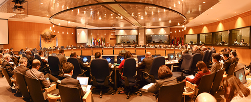
The ICAO Council made important headway on 27 June on the key international standards supporting the planned timeline for the UN aviation agency’s Carbon Offsetting and Reduction Scheme for International Aviation, or CORSIA, during its 214th Session.
This adoption of the First Edition of Annex 16, Volume IV, to the Convention on International Civil Aviation (Chicago Convention), comes less than two years after ICAO’s 192 Member States achieved their historic agreement on CORSIA at the Organization’s 39th Assembly, an emissions-offsetting first for any global industry sector.
In the words of ICAO Council President Dr. Olumuyiwa Benard Aliu: ‘Gaining agreement on this new Volume IV to Annex 16 is critical to helping States and airlines to operationalize CORSIA per its established deadlines.’
ENC 2019 announcement
Organised by the Polish Navigation Forum, the 2019 edition of the European Navigation Conference will take place in Warsaw, Poland, 8-12 Aprl, 2019.
/>“Welcome! On behalf of European Group of Institutes of Navigation (EUGIN) and the Polish Navigation Forum (PNF), I invite you to participate in the next edition of European Navigation Conference, ENC 2019. Looking forward to seeing you in Warsaw!”
Krzysztof Czaplewski, Chairman of the ENC 2019 Organizing Committee
COMMOCEAN 2018, the 3rd International Marine Science Communication Conference
CommOCEAN 2018 aims to provide communication skills and inspiration to communicators across a range of experience levels. Many sessions are suitable for all, but some elements of the programme will run simultaneously and are tailored for those looking to build their communications skills and to those looking to move their communications to the next level. Delegates should choose the most appropriate sessions for their skills level.
The core programme will offer inspiring and insightful addresses from leaders in marine science communication, presentations and workshops covering communications techniques and platforms, and examples of marine science research communications campaigns. The event will also feature talks on current marine science projects and an exhibition of public engagement materials and techniques.
Sharm El Sheikh – as seen by Sentinel-2
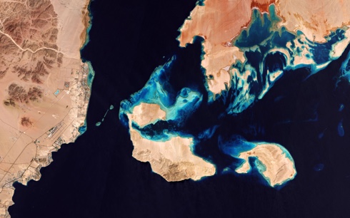
Description: Id 396541 ESA ©
The Copernicus Sentinel-2 satellite provides a view over Sharm El Sheikh, Egypt. Famous as a resort on the southern tip of the Sinai Peninsula, this coastal strip along the Red Sea is peppered with bars, restaurants and hotels. The ancient Greeks and Romans are thought to have taken their holidays in Egypt as long ago as the 4th century BC.
This striking true-colour image shows the Gulf of Aqaba at the top centre, feeding into the Red Sea – home to some of the hottest and saltiest seawater in the world. The Red Sea is connected to the Mediterranean Sea via the Suez Canal, one of the world’s busiest waterways.
Aeolus preparing to fly the wind mission

Copyright ESA/ATG medialab ©
ESA’s Aeolus wind mission will provide timely and accurate profiles of the world’s winds and further information on aerosols and clouds. This mission will advance our understanding of atmospheric dynamics. It will also provide much-needed information to improve weather forecasts and contribute to climate research.
The satellite, an example shown here, carries a single instrument: a Doppler wind lidar (light+radar) called Aladin. This sophisticated instrument is designed to probe the lowermost 30 km of the atmosphere along the satellite’s orbital path. Comprising a powerful laser, a large telescope and a very sensitive receiver, Aladin will be the first wind lidar in space. In cloud-free air the lidar will probe the atmosphere down to the surface, or to the top of dense cloud.
Looming iceberg

This satellite image, captured by Sentinel-2A on 9 July 2018, shows a huge iceberg perilously close to the village of Innaarsuit (indicated in red) on the west coast of Greenland. It is understood that if the berg breaks apart, waves resulting from the falling ice could wash away parts of the village.
Here the 169 residents of Innaarsuit are relatively used to seeing large icebergs floating by, but weighing around 10 million tonnes, the berg shown is reported to be the largest in memory. With chunks of ice calving from the iceberg, a number of residents were evacuated amid fears of a bigger break up.
INC 2018 – call for papers
This is the formal announcement as a Call for Papers in respect of INC 2018. It is important to mention that delegates from last year’s event, INC2017, referred to it as: “an excellent conference for information exchange and updating knowledge”, and “every year opportunities at INC are increasing and it has become a very interesting forum to attend.”
Deadline for sumission is July, 27, 2018.
Autonomous deep water survey vessel
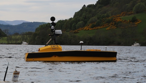
It was announced from Portsmouth on 16 July that ASV Global (ASV), in partnership with Sonardyne International Ltd., the National Oceanography Centre (NOC) and SeeByte, have successfully delivered a long-endurance, multi-vehicle, autonomous survey solution.
A recent two-week trial in Scotland’s Loch Ness was the culmination of the three-year Autonomous Surface and Sub-surface Survey System collaborative project, part-funded by Innovate UK and Dstl.
The aim of the project was to deliver an integrated system to perform low cost, full water column marine surveys using multiple autonomous systems.
CANSO call for action
On 13 July CANSO, the Civil Air Navigation Services Organisation, announced that it is seeking strong cooperation and a greater sense of urgency to address the forecast air traffic capacity shortages and delays in Europe.
It welcomes and supports the joint call for action from the European Commission and the European Parliament. CANSO and its Members are working hard to improve air traffic management performance in Europe but States need to ensure a pan-European approach with more cross-border cooperation, adequate funding for infrastructure expansion and modernisation, and appropriate performance-based regulation.
IHMA’s new President
The International Harbour Masters’ Association (IHMA) is delighted to announce that its new President is Captain Allan Gray, Harbour Master, Port of Fremantle, Australia.
Captain Gray had a 20 year career at sea and traded in various vessels including ro-ro, container, bulk carriers and LPG tankers. On coming ashore he was a Vessel Traffic Manager at Mackay/Haypoint and Reefcentre. He joined Fremantle Ports in July 2006 as Deputy Harbour Master and was appointed Harbour Master in September 2008. Captain Gray was previously the Federal Master for the Company of Master Mariners Australia and was later awarded Life Membership.
The first International Harbour Masters’ Association (IHMA) Port Operations Awards


IHMA is delighted that its initiative to introduce awards highlighting the contribution of people and organisations to port operations has met with such a positive response. The first ever IHMA awards were announced at the Association’s biennial Congress Dinner held at the Headquarters of the International Maritime Organization on 27 June 2018.
The Safe, Efficient and Secure Port Award to Pilbara Ports Authority for Under-Keel Clearance Management at Port Hedland in conjunction with IHMA Commercial Member OMC International.
The Outstanding Individual Achievement in the Profession of Harbour Master Award to Captain Andreas Mai, Harbour Master, Port of Bremerhaven and Bremen.
The Port Operations Photograph of the Year Award to the Harbour Master’s Office of the Port of Rotterdam for its photo of a hybrid patrol vessel (illustrated).
Galileo makes ready

Europe’s next four Galileo satellites have been fuelled at Europe’s Spaceport in Kourou, French Guiana, in preparation for their launch on 25 July. The European Space Agency (ESA) reported on 3 July that the four satellites were placed in their protective containers to be transported from the S1A processing building to the S3B payload preparation building, where they were filled with the hydrazine fuel that will keep the satellites manoeuvrable during their 12-year working lives.
It is understood that the next step is to fit the quartet onto the dispenser that holds them in place securely during launch and then releases them into space once the upper stage of the Ariane 5 rocket reaches its 22,922 km altitude target orbit.
13th Arctic Shipping Summit
ACI’s Arctic Shipping Summit is moving to Hamburg, Germany for its 13th gathering in the series and will take on a new look for December 2018, it is reported. ACI are bringing together stakeholders from all parts of the Arctic to discuss their involvement in the ever-changing Northern Shipping Route.
The two day conference will see an assembly of companies and organisations such as coast guards, senior Arctic government officials, shipping companies, LNG projects, lawyers, P&I Clubs, arctic researchers and lecturers and more. This is expected to allow for an interactive and open conference with much networking and discussion.
UK and Irish waters Differential GPS user survey
The General Lighthouse Authorities of the UK and Ireland are conducting a survey to gauge current and future user requirements for their Differential GPS service. This was announced at the end of June 2018.
The authorities are now surveying users across a wide variety of sectors to better understand how the Differential GPS service is being used. The Differential GPS service currently provides corrections for GPS (single frequency) only, but the technology is being developed to enable corrections to be provided for all Global Navigation Satellite Systems (GNSS), should there be a requirement. The survey results will be used to establish current and future user needs.
It is important for respondents to understand that this is a survey about the
Differential GPS service and not GPS/GNSS. You can complete the survey online or download this form for offline completion.
Historic trans-Atlantic flight planned


A new Remotely Piloted Air System (RPAS) ordered for the Royal Air Force will fly non-stop from the United States to RAF Fairford in the UK on 11 July. The UK is the lead customer for the next-generation aircraft which will be known as the Protector RG Mk.1 when it enters service in the early 2020s.
Operated at all times by a fully qualified pilot, Protector is the World’s first RPAS to be designed, built and certified against stringent NATO and UK Safety Certification standards equivalent to manned aircraft. The flight from North Dakota to Gloucestershire is likely to take over 20 hours and will be the first across the Atlantic by a Medium Altitude RPAS and the first time one has entered UK airspace under beyond line-of-sight communication control.
mv Ruyter grounding

In summary, the MAIB report (No11/2018 published on 20 June 2018) indicates that at 2311 on 10 October 2017, The Netherlands registered general cargo vessel Ruyter (89.99m loa; 2528gt; built 2006) on passage from Skagen, Denmark to Warrenpoint, Northern Ireland, ran aground on the north shore of Rathlin Island. It was found that the master who was the watchkeeper had left the bridge unattended. The bridge navigational watch alarm system, which could have alerted the chief officer to the fact that the bridge was unmanned, had been switched off.
It was found that the master had been consuming alcohol prior to taking over the watch but the chief officer, who had previously warned the master against excessive consumption of alcohol, had been satisfied that the master was fit for watchkeeping duties.
Saab to deliver integrated ATC suite to Santiago

It was announced by Saab on 21 June that it had been selected to deliver the next generation of air traffic control safety equipment to Comodoro Arturo Merino Benítez International Airport in Santiago, Chile.
Saab was selected through an open competition to provide a new generation air traffic safety system in Santiago. This system includes fully integrated tower working positions with a ground display, electronic flight strips, and a general information display. In addition, the system will feature A-SMGCS level safety alerting, Saab multilateration and the Saab SR-3 Surface Movement radar.
16th IAIN World Congress
A reminder that IAIN 2018 will be held from 28 November to 1 December at Makuhari Messe, Chiba, Japan, and bring together researchers, engineers, companies and related institutions from around the world to present research and to engage in lively discussion. Much interest has been shown in this event.
A reminder with regard to the submission of abstracts informs that this will be closed on 30 June 2018. Also here.
The ION (US) ITM and PTTI 2019 event
Abstracts are invited for the ION’s combined International Technical Meeting (ITM) and the 50th Anniversary of the Precise Time and Time Interval (PTTI) Systems and Applications Meeting. The co-located conferences will take place from 28 to 31 January 2019 at the Hyatt Regency Reston, Reston, Virginia.
Abstracts are due on 10 October 2018.
ITM and PTTI 2019 are co-located in that one registration fee covers two technical events, a commercial exhibit, and the 50th Anniversary of PTTI.
– ITM is the ION’s winter meeting with peer-reviewed technical papers related to positioning, navigation and timing and includes the ION Fellows and Annual Awards presentations.
– PTTI is the annual technical conference designed to disseminate and coordinate PTTI information at the user level; review present and future PTTI requirements; inform government and industry engineers, technicians and managers of precise time and frequency technology and its problems; and provide an opportunity for an active exchange of new technology associated with PTTI.
At the same time a special joint plenary session will celebrate the 50th Anniversary of PTTI.
ABPmer to support the development of Ireland’s marine plan
Recognised specialist in marine planning, ABPmer, has been appointed to support the development of a marine spatial plan (MSP) for Ireland. This marine plan will cover Ireland’s maritime area, including internal waters (sea area), territorial seas, exclusive economic zone (EEZ) and continental shelf. It is intended that a single plan will be prepared for the entire area with the possibility of more detailed regional plans being made at a later date.
It is understood that Ireland transposed the MSP Directive (EU Directive 2014/89/EU) through the European Union (Framework for Maritime Spatial Planning) Regulations in June 2016. These regulations established the legal basis and broad framework for Ireland to implement marine spatial planning through the development of an MSP (or plans) on a ten-year cycle. During 2017, a marine planning function was set up within the Irish Department of Housing, Planning and Local Government and in December 2017 it launched its roadmap for delivering a national marine spatial plan.
Poland’s World Maritime Day parallel event
How to create better shipping for a better future was a theme running throughout the 2018 IMO World Maritime Day Parallel Event held from 13-15 June in Szczecin, Poland.
In the words of IMO Secretary-General Kitack Lim (illustrated), in his keynote address: ‘IMO’s heritage for 70 years has been to drive improvements in shipping to achieve a better world today. But we cannot rest on past achievements. Our challenge for the years to come remains the same: to create better shipping – for a better future.’
South Africa: a hub for Marine Aids to Navigation training


It was reported from Cape Town towards the end of May that South Africa is emerging as a hub of training in marine aids to navigation (AtoNs) for other developing countries keen to establish their maritime transport sector as a safe, secure and environmentally sound pillar of socio-economic growth. This was clear from an address by David Gordon, Executive Manager: Lighthouse and Navigational Systems (LNS) of Transnet National Ports Authority (TNPA) at the Pre-Conference Forum of the 19th IALA Conference in Incheon, Republic of Korea on 26 May.
He said: ‘South Africa is recognised as the centre of excellence in Africa with regard to AtoNs. It is therefore important that South Africa leads the way in ensuring that the African continent on the whole is led by competent individuals and organisations in order to achieve compliance with international
legislation.’
Antarctica in 2070: what future will we choose


Choices made in the next decade will have long-term consequences for Antarctica and the globe, according to research published on 14 June by the journal Nature. The study explores how Antarctica and the Southern Ocean will change over the next 50 years, and how those changes will impact the rest of the globe. This was reported by CSIRO on 14 June.
Two scenarios are considered: one in which greenhouse gas emissions remain unchecked, and one in which strong action is taken to limit emissions and to manage increased human use of Antarctica.

