UK Space Agency seeks international partnerships

At the end of July it was announced by the UK Space Agency that it is working with research institutions, industry and non-profit organisations to develop strong international partnerships to help tackle economic, societal and environmental issues using satellite technology.
It is understood that the Agency will award funding through its International Partnership Programme (IPP), which is designed to partner UK space expertise with overseas governments and organisations. This is part of the Global Challenges Research Fund (GCRF), which aims to support cutting-edge research and innovation that addresses the challenges faced by developing countries.
Ten small and medium sized enterprises (SMEs) and research organisations have been given a total of £338,000 to use to establish partnerships in countries including Zambia, Ethiopia and Vietnam.
ICAO President urges cooperation in airspace management for unmanned aircraft

Opening the ICAO Remotely Piloted Aircraft Systems Symposium (RPAS) in Abuja on 18 July, ICAO Council President Dr Olumuyiwa Benard Aliu stressed the importance of a globally coherent regulatory framework for the management of unmanned air traffic. He remarked: ‘If you consider a company envisaging a global drone fleet to enhance its deliveries, the value of having a myriad of domestic national regulations aligned via globally harmonized international standards becomes clearly apparent.’
President Aliu also stressed the complexity of this task, notably in terms of the tremendous diversity of types and applications of Unmanned Aircraft Systems
(UAS), and the need to place safety first.
Vega liftoff

On the morning of 2 August Arianespace launched a Vega rocket carrying two Earth observation satellites for Italy, France and Israel encased in Vega’s lighter protective fairing.
Liftoff of Vega’s tenth mission from Europe’s Spaceport in Kourou, French Guiana came at 0158 GMT (0358 Central European Summer Time) or 2258 local time on a mission lasting 97 minutes to deliver Optsat-3000 and Venµs into their planned orbits. Optsat-3000 will provide Italy’s Ministry of Defence with global high resolution images. With a mass of 368 kg, it was the first to be released after about 42 minutes. The 264 kg Venµs was released 49 minutes later. Venµs (Vegetation and Environment monitoring on a New Micro Satellite) sponsored by France and Israel will study vegetation and the environment, and demonstrate a new electrical propulsion system.
Optsat-3000 has a design life of seven years and Venµs four and a half years.
Aviation priorities for Brexit negotiations: The Air League’s view

Founded in 1909, The Air League’s mission is to enhance national understanding of the importance to the UK of aviation and aerospace. The Air League’s vision is to ensure continued recognition by leaders in the UK that a strong aviation and aerospace sector is essential to the economic prosperity and security of the UK.

At the end of July the League published a second briefing paper on Aviation and Brexit. This document seeks to contribute positively to the debate to help ensure the continued contribution the sector makes to the prosperity, employment, global connectivity, and economic development of the UK.
Working within an EU framework has helped the UK aerospace and air transport sectors to develop and prosper with a minimum of cross-border restrictions in Europe, operating to common standards, facilitating market access, free from customs and tariff restrictions.
Simulation makes perfect
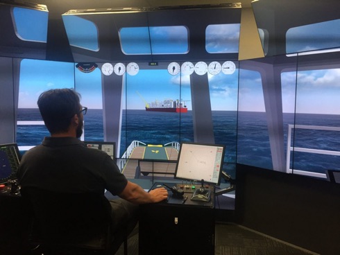
At 488metres loa Shell’s Prelude FLNG facility was always going to represent a formidable challenge even for the skilled tug masters who were charged with towing the facility from the shipyard in the Republic of Korea where it was constructed, and delivering it to its final destination, a remote gas field 475 kilometres off the coast of Western Australia. This was reported by HR Wallingford, UK, on 1 August.
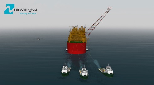
Practice makes perfect, and HR Wallingford, using its Australia Ship Simulation Centre in Fremantle created an accurate and detailed navigation simulation of Prelude for Shell, which was used to prepare the Tow Masters, Tug Masters and Pilots, allowing them to familiarise themselves with a realistic simulation of Prelude manoeuvres at sea. On 25 July Prelude arrived safely at its destination in the East Browse Basin.
SeaRobotics and autonomous hydrographic survey vehicles
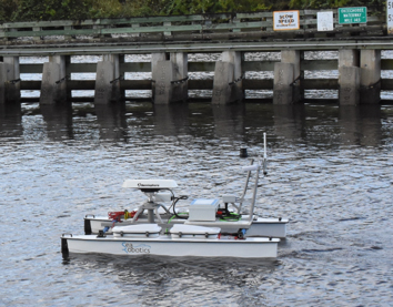
SeaRobotics Corporation (SeaRobotics) reported on 31 July that it had delivered two complete autonomous 2.5 metre unmanned surface vehicles (USVs) to a government hydrographic service. These USVs, built by SeaRobotics, are complete hydrographic systems providing multibeam echo sounders (MBES), support sensors, a cast winch, deployment carts, and road trailers.
This contract reinforces the commitment government and commercial entities are making to take unmanned surface vehicles out of the laboratory and research environment and integrate them into the world of professional surveyors.
Efficiency and cost effectiveness of each application will be reviewed, and a profile of high-productivity, cost-reducing activities will be developed. Both traditional survey tasks and previously denied areas that remain unsurveyed will be evaluated, it is understood.
El Niño events

– undertake deep sea oceanography;
– map and study the geology of Australia’s marine estate to underpin resource exploration;
– monitor and better understand Australia’s fisheries, and
– learn more about Australia’s weather patterns and large ocean processes.
The frequency of extreme El Niño events is projected to increase for a further century after global mean temperature is stabilised at 1.5°C above pre-industrial levels.
Research published on 24 July in Nature Climate Change by an international team shows that if warming was halted to the aspirational 1.5°C target from the Paris Agreement, the frequency of extreme El Niño events could continue to increase, due to a continuation of faster warming in the eastern equatorial Pacific.
CSIRO researcher and lead author Dr Guojian Wang said the growing risk of extreme El Niño events did not stabilise in a stabilised climate.
ION (US) PLANS 2018

In the US the Position Location and Navigation Symposium (PLANS) is a biennial technical conference that occurs in the spring of even numbered years. Aim of the symposium is to provide a forum to share the latest advances in navigation technology.
The PLANS conference is a four day event with one day dedicated to tutorials and three days to technical sessions. Tutorials provide delegates with the opportunity to learn about navigation technology from well-known industry experts. Twenty-four half-day technical sessions are offered over a three-day period, with four sessions running simultaneously each morning and afternoon. At the technical sessions scientists, researchers and engineers from around the world present their latest work in the field of navigation.
2018 Israel Navigation workshop and exhibition
The Israel Navigation Workshop and Exhibition (INWE18) is a biennial event organized and sponsored by the Israel Association for Automatic Control (IAAC), a Member Institute of IAIN.
INWE18 will be a one-day event dedicated to technical talks in navigation systems ranging from fundamental research, to applications and to field test results.
Topics of interest include positioning, navigation and timekeeping in all their variations, sensors, systems, optimal integration of multiple sensors, and novel or emerging technologies in the field of navigation.
In parallel with the talks there will be hosted a technical exhibit in which navigation equipment manufacturers and systems suppliers will have the opportunity to show their current products and most recent technical innovations.
US assesses mitigation tactics against jamming

Nearly 100 federal, state, and local public safety and private organizations gathered in week ending 22 July to test tactics and technologies to identify, locate and mitigate illegal jamming of communications systems, such as GPS, radio and wireless systems.
The 2017 First Responder Electronic Jamming Exercise (JamX 17) was hosted by the Department of Homeland Security (DHS) Science and Technology Directorate (S&T) from 16-22 July, at the Department of Energy’s Idaho National Laboratory in Idaho Falls, Idaho.
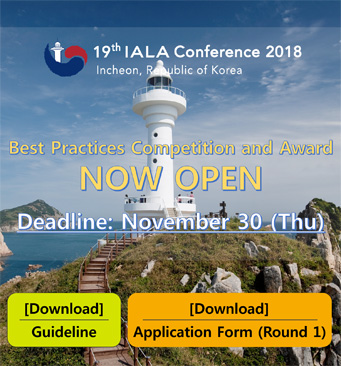
The 19th IALA Conference Best Practices Competition

The 19th IALA Conference will be held in Incheon, Republic of Korea, from 27 May to 2 June 2018. The theme will be Successful voyages, Sustainable planet.
As part of the Conference a Best Practices Competition will be held there on 31 May 2018. This is to encourage individual working groups, teams, or organisations to share their best operational and managerial practices, process, systems, and initiatives, and learn from the experience of others. It provides an opportunity to celebrate the achievements of individuals and teams who have been responsible for creating and/or managing the introduction and deployment of best practices.
Updated Drone Assist app to propel responsible flying

Drone Assist, the drone safety app launched by the (UK) National Air Traffic Service (NATS) in December 2016 and developed in partnership with Altitude Angel, has undergone a number of changes and improvements to make it even more user-friendly for commercial and recreational drone pilots. This was reported by NATS on 19 July.
Created to help drone pilots fly responsibly, one of the most significant changes to the app is the Fly Now feature. Drone pilots can now plan their flights ahead of time, for any location in the UK, whereas previously this could only be done in the location being flown at the time of flight. This update better supports commercial drone operators as well as any drone operator operating with limited connectivity and means that pilots can now plan ahead.
EfficienSea2: smart buoy deployed in Polish waters
The European project EfficienSea2 is testing a new Smart Buoy which will enable vessels to have improved navigational services and to receive data in support of operations when reaching port.
The Maritime Office in Gdynia, Poland, is testing a newly developed Smart Buoy which will allow port authorities and ships to collect information about weather, wave height and depth of water and then share that information with nearby users in a completely autonomous system. Development of the Smart Buoys has been based on user requirements from pilots and VTS officers, and aids to navigation administration staff.
These Smart Buoys, which include an AIS/GPS module, hydro-meteorological sensors and GSM/radio hardware able to connect to cellular networks, have already been laboratory tested. They are now ready to be subjected to a marine environment.
Partners in Innovation: HM Land Registry and Ordnance Survey

A new strategic partnership between HM Land Registry (HMLR) and Ordnance Survey (OS) to help propel the UK towards becoming a global leader in the land and property market.
This pilot partnership, announced on 19 July, will see HMLR join OS at its Geovation Hub to encourage and support innovation and property technology (PropTech) businesses.
Geovation is based at a dedicated location-data lab in London that supports and enables open innovation and collaboration across many sectors. The Geovation mission is to expand the use of location and land and property data in the UK’s innovation business community.
(UK) Business Minister Lord Prior said: ‘The Geovation Hub is already making important contributions to a wide range of industries, including telecommunications, energy, transport and water management. Location-based data has a crucial role in future technology development and innovation from driverless cars to the Internet of Things.’
GNS and Cybersecurity

From the GB-based Global Navigation Solutions comes news that mariners have been advised to exercise extreme caution when sailing in the Black Sea after a major cyber incident occurred in June. Confirmed reports have shown that numerous vessels were affected with their GPS signals being interrupted causing some confusion onboard.
This incident and the recent cyber attack on shipping giant Maersk demonstrates that the risk to mariners in respect of cyber security is significantly increasing.
GNS has produced six simple steps to help the user mitigate cyber risk.
The ION (US) journal Navigation experiences significant growth

On 11 July the (US) Institute of Navigation announces that its quarterly journal Navigation experienced significant growth in the Journal Impact Factor measurement tool.
The Journal of The ION, reflected in the latest Journal Impact Factor (JIF) report. The JIF of an academic journal is a measurement tool used to calculate the yearly average number of citations to recent articles published in a journal and is an indication of the relative importance of the journal within its field. It is generally recognized that journals with higher impact factors are deemed more important than those with lower ones due to its citation rate.
Navigation’s Journal Impact Factor is now 1.604, an increase from 0.979 last
year and 0.562 the year before. Total citations have increased by more than
270% over the past two years.
Alert! Compendium – educational resource launched
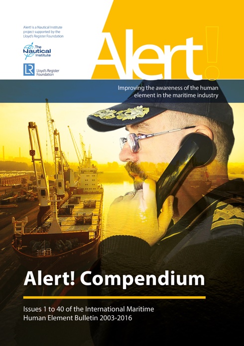
A vital global educational resource on the human element was launched on 12 July for the benefit of the whole maritime industry. Lloyd’s Register Foundation and The Nautical Institute have joined together in producing a special limited edition bound set of all 40 issues of Alert! the human element bulletin.
It is understood that enough have been produced for every maritime training college in the world to have a copy so all will have access to the topics and case studies covered by the project over its 14-year history.
The volume acknowledges the enduring significance of these topics and the continued role of Alert! bulletins in helping to improve safety at sea, said Professor Richard Clegg, Foundation Chief Executive, Lloyd’s Register Foundation, which has funded the project.
As a result of the project some 2.5 million of the four series of Alert! bulletins comprising 350 articles had been distributed around the world; 21 innovative videos were produced for free download and a reference library of 250 papers has been made available online.
Denmark to host major international maritime conference
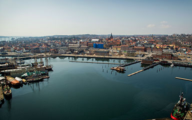
The Danish Maritime Authority (DMA) announced that in 2024, Denmark will be hosting European Maritime Day with more than 1,000 participants. With its maritime surroundings, the city of Svendborg will be the setting of the conference.
Anholt Lighthouse under restoration

Renovation work on Anholt Lighthouse has begun and is expected to be completed in late October. During this time attention will be paid to the station’s brickwork, windows and doors. This was announced by the Danish Maritime Authority on 6 June.
Anholt Lighthouse is one of Denmark’s oldest. It was established in 1561 following a Royal Resolution of 1560 when it was decided to construct four strategic lighthouses in Denmark. It therefore represents an important part of the Denmark’s maritime cultural past. The first brick-built lighthouse on the island of Anholt was established in the years 1785-1788.
Efficiensea2 Workshop at IALA
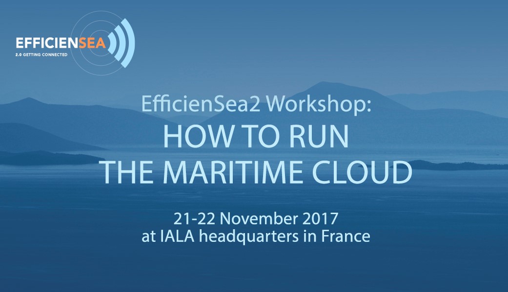
The Maritime Cloud is a communications framework that enables efficient, secure, reliable and seamless electronic information exchange among all authorized maritime stakeholders across available systems.
This framework is currently under development in collaboration between different projects: EfficienSea2 (EU), Sea Traffic Management – the STM validation project (EU) and the SMART Navigation project (Republic of Korea).
As a partner in the EfficienSea2 project, IALA is participating in the work on maturing the Maritime Cloud, in order to assess its potential as the generic communication framework for e-Navigation at large.
It is in this role of being a partner in the EfficienSea2 project that IALA is organising and hosting this workshop.
The Nautical Institute launches the Ice Navigator Scheme

On 3 June The Nautical Institute launched the Ice Navigator Training and Certification Scheme. This is the latest in the Institute’s expanding series of professional training schemes and has been developed in response to rapidly growing demand for officers with proven expertise in handling ships in ice.
Captain Duke Snider FNI, (photo), President of The Nautical Institute: ‘Operating ships within any ice regime requires specialist knowledge, skills and a level of awareness beyond those of the majority of mariners. This course will help to equip ships’ officers to meet the unique challenges posed by navigating in ice.’
Sites to watch #3
The Resilient Navigation and Timing Foundation (RNT Foundation) is a non-profit, public benefit corporation that helps protect critical infrastructure by promoting resilient navigation and timing worldwide. The Foundation has strong views on GPS and GNSS.
Other sites featured are: the United States Coast Guard Navigation Center, the Norwegian Armed Forces Forum website and particularly this page reporting the demolition of Loran aerials in Norway, this wonderful collection of material on hydrographic and related topics, a free subscription to receive regular breaking maritime news and IALA-AISM’s Annual Report for 2016.
eMaritime Group Bridge Team ECDIS Audits
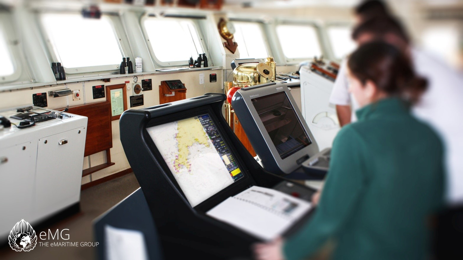
The eMaritime Group (eMG) offer a range of services including onboard Bridge Team ECDIS audits. In recent months, their navigation auditors have been sent widely abroad including to Spain, Italy, The Netherlands and Malta.
Aim of the audit is to provide the shipmaster, management company or operator with an objective assessment of the state of the bridge team and associated administration and equipment. The intense one-day procedure can be conducted worldwide, it is understood, be it alongside or underway and includes the whole bridge team and highlights every aspect of navigation.
Royal Navy’s flagship leaves for sea trials
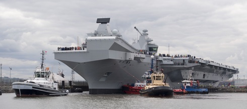


History was made on 26 June as HMS Queen Elizabeth, the first Queen Elizabeth Class aircraft carrier, set sail from Rosyth to commence first stage sea trials off the north-east of Scotland.
Three years after she was officially named by HM the Queen, the nation’s future flagship will spend an initial period of around six weeks at sea to test the fundamentals of the ship. The sea trials will monitor speed, manoeuvrability, power and propulsion as well as undertaking weapons trials and additional tests on her levels of readiness. Following this initial period, HMS Queen Elizabeth will return to Rosyth for further testing and maintenance before heading back to sea for a second stage which aims to test her Mission Systems. She will transit to her home port of Portsmouth Naval Base to be handed over to the Royal Navy later this year.
Report on the 1st IHO Assembly, April 2017
![]()
Mr. John Pepper, Director of OceanWise Ltd., prepared this report on the first Assembly of the International Hydrographic Organisation, held at the Auditorium Rainier III in Monaco, 24-28 April 2017. IAIN holds representative status in several international organisations.
More documents here.