IAIN World Congress report
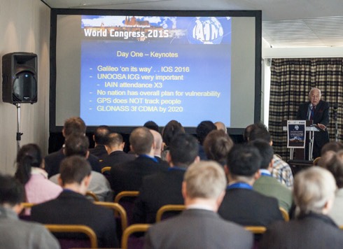 A session under way during the 15th IAIN World Congress held at the Corinthia Hotel, Prague.
Professor David Last gave the keynote address on the Navigation of Navigation. He pointed out that navigation had been taken out of the hands of the professionals and specialists and become a ‘consumer product’. There was no clear plan to handle this development. GPS/GNSS meets all needs, but there are concerns about vulnerability, including jamming and spoofing. Hardening, alternatives, multiple systems, Receiver Autonomous Integrity Monitoring (RAIM), reversion to traditional methods all have a place. eLoran is the only cost-effective solution available at present, but it has not been delivered yet. It has been shown to work and could be commercially operated, but there are no clear plans anywhere – Governments cannot handle the problem and he believed the navigation community is approaching the end of the era of systems, with vertical integration. Multiple GNSS are components of a system. They live and die together and here a flight plan is needed.
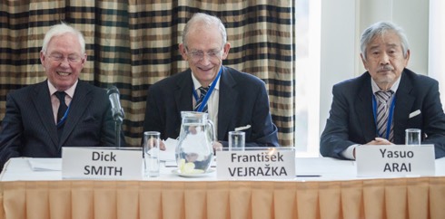 Professor František Vejražka of the Czech Institute of Navigation, centre, with at left, Captain Dick Smith, President of the IAIN and Professor Yasuo Arai of the Japanese Institute of Navigation. At the close of the Congress IAIN Honorary Membership was conferred on Professor Vejražka and Professor Arai was advanced to President.
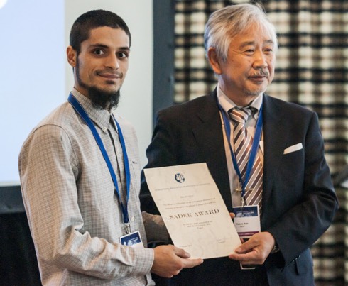 David Calero of Spain was presented with the Sadek Award for the best paper presentation.
Illustrations reproduced by kind permission of Guarant International spol.s.r.o.
IAIN World Congress report
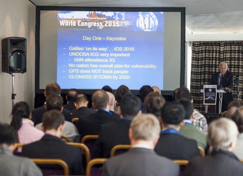 A session under way during the 15th IAIN World Congress held at the Corinthia Hotel, Prague.
Professor David Last gave the keynote address on the Navigation of Navigation. He pointed out that navigation had been taken out of the hands of the professionals and specialists and become a ‘consumer product’. There was no clear plan to handle this development. GPS/GNSS meets all needs, but there are concerns about vulnerability, including jamming and spoofing. Hardening, alternatives, multiple systems, Receiver Autonomous Integrity Monitoring (RAIM), reversion to traditional methods all have a place. eLoran is the only cost-effective solution available at present, but it has not been delivered yet. It has been shown to work and could be commercially operated, but there are no clear plans anywhere – Governments cannot handle the problem and he believed the navigation community is approaching the end of the era of systems, with vertical integration. Multiple GNSS are components of a system. They live and die together and here a flight plan is needed.
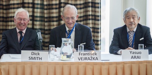 Professor František Vejražka of the Czech Institute of Navigation, centre, with at left, Captain Dick Smith, President of the IAIN and Professor Yasuo Arai of the Japanese Institute of Navigation. At the close of the Congress IAIN Honorary Membership was conferred on Professor Vejražka and Professor Arai was advanced to President.
 David Calero of Spain was presented with the Sadek Award for the best paper presentation.
Illustrations reproduced by kind permission of Guarant International spol.s.r.o.
ESAVS 2016
The International Symposium on Enhanced Solutions for Aircraft and Vehicle Surveillance Applications, ESAVS 2016, will be held in Berlin on 7 and 8 April next year organised by the German Institute of Navigation (DGON). A call for papers has been issued along with deadlines, the programme committee and other material.
Investing in airports
conference

ICAO report that the Investing In Airports Conference is less than one month away.
The theme is Investing in Airports, Economic Oversight and Regulation. This event is organized by Airports Council International (ACI), in co-operation with the International Civil Aviation Organization (ICAO).
The conference will provide an unprecedented opportunity to discuss economic oversight and regulation with a variety of aviation stakeholders, including ICAO, state regulators, airport operators, airlines and investors. According to a statement issued by ICAO this event marks the first time a full conference will be dedicated to learning about how changes to airport governance models and airport management practices are encouraging regulators worldwide to take new approaches to airport oversight and regulation.
Participants will also have an opportunity to engage in a pre-conference workshop where regulatory frameworks and airport governance and investment structures will be addressed.
Further details may be obtained here.
NTSB presents ATC safety seminar
 It was announced from Washington on 10 November that the National Transportation Safety Board (NTSB) is presenting a seminar regarding air traffic control in the general aviation environment. This seminar will be held on 12 December at the NTSB’s Training Center in Ashburn, Virginia. The NTSB has partnered with the Federal Aviation Administration (FAA) for this useful and educational seminar.
Attendees will have the rare opportunity to hear from local FAA Air Traffic Controllers, who will discuss policies and procedures which are important for pilots to understand while navigating through one of the most complex and busiest airspace locales in the Washington DC Terminal area. They will also discuss phraseology and communication procedures for pilots to be able to navigate the local airspace with ease.
Report on
Resilient PNT Forum IV


![]()
IAIN held its 15th World Congress in Prague from 21-24 October 2015. The fourth Forum on Resilient Positioning, Navigation and Timing (PNT) was held on 20 October 2015, immediately preceding the Congress.
Motivation has been the increasing reliance on Global Navigation Satellite Systems in all transport sectors, for timing and other essential infrastructure throughout the world. The inherent vulnerability of GNSS to disruption makes it essential to provide resilient supporting systems, particularly for safety of life and economically critical applications. Robust systems in the presence of interference, with integrity monitoring and authentication, can only be achieved through cooperative efforts by industry, administrations and user groups.
Report on
Resilient PNT Forum IV


![]()
IAIN held its 15th World Congress in Prague from 21-24 October 2015. The fourth Forum on Resilient Positioning, Navigation and Timing (PNT) was held on 20 October 2015, immediately preceding the Congress.
Motivation has been the increasing reliance on Global Navigation Satellite Systems in all transport sectors, for timing and other essential infrastructure throughout the world. The inherent vulnerability of GNSS to disruption makes it essential to provide resilient supporting systems, particularly for safety of life and economically critical applications. Robust systems in the presence of interference, with integrity monitoring and authentication, can only be achieved through cooperative efforts by industry, administrations and user groups.
NTSB El Faro investigation update
 On 3 November NTSB advised that it had contracted with the US Navy to locate the El Faro, victim of tropical storm Joaquin, document the wreckage and debris field and recover the voyage data recorder (VDR).
The El Faro has indeed been found, but the voyage data recorder is still missing. The navigation bridge and the deck below have separated from the vessel
and have not been located (yet).
Wreckage of cargo ship
believed to be El Faro located
 It was announced from the (US) National Transportation Safety Board (NTSB) in Washington on 31 October that a search team on board the USNS Apache has found the wreckage of a vessel that they believe to be the cargo ship El Faro, which went missing on 1 October during Hurricane Joaquin. The vessel was located at a depth of about 15,000 feet in the vicinity of her last known position.
Sophisticated sonar equipment towed from Apache first detected what are
believed to be images of the vessel using Orion, a side-scanning sonar system,
at about 1336 ET on 31 October during the fifth of 13 planned search line surveys.
To confirm the finding, specialists on Apache will use CURV 21, a deep ocean remotely operated vehicle, to survey and confirm the identity of the wreckage. This survey was due to commence on 1 November.
100 years of Australian lighthouses
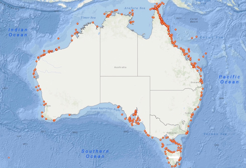
On 1 July this year 100 years ago, the Commonwealth of Australia officially
accepted responsibility from the state and territory governments for all
lighthouses around Australia.
To mark its special day, AMSA developed an interactive Lighthouse page on its website, which lists all Australian heritage lighthouses under their management.
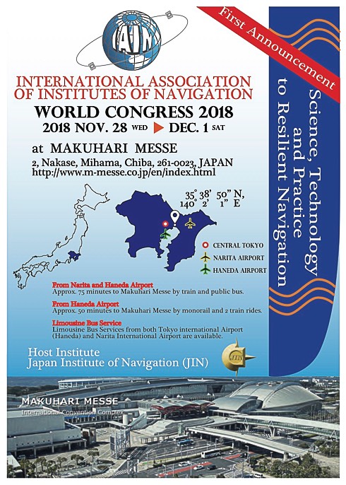
16th IAIN World Congress announced
The 16th IAIN World Congress is to be held in Chiba, Japan, starting November 28, 2018.
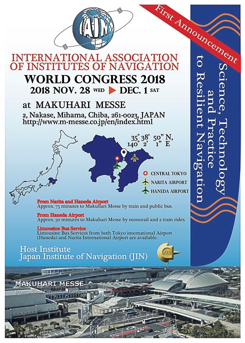
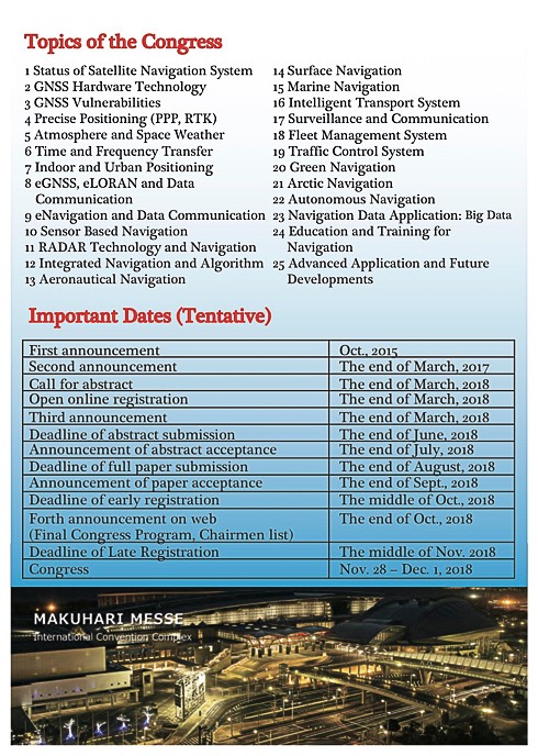
16th IAIN World Congress announced
The 16th IAIN World Congress is to be held in Chiba, Japan, starting November 28, 2018.
President Xi Jinping at
Inmarsat London HQ
 From left to right: President Xi Jinping, Rt Hon Greg Hands MP, Chief Secretary to the Treasury, Rupert Pearce, CEO of Inmarsat. – Photo © Inmarsat
On 22 October Inmarsat welcomed the President of the People’s Republic of China, Mr Xi Jinping to its London headquarters, as part of the President’s historic State Visit to the UK.
The prestigious visit reflects the close working relationship between Inmarsat and China. China was one of the 86 countries that came together to found Inmarsat with a maritime safety mandate and over 35 years later Inmarsat continues to contribute to safety and security in the maritime and aviation worlds and, more recently, during disasters in China.
President Xi, accompanied by HRH The Duke of York, the Chinese Ambassador to London, HE Liu Xiaoming, the Rt Hon Greg Hands and Inmarsat executives, viewed Inmarsat’s Network Operations Centre to understand how Inmarsat is able to uniquely contribute to President Xi’s One Belt One Road (OBOR) strategic vision through the provision of critical global mobile broadband connectivity services, including Inmarsat’s revolutionary new service, Global Xpress.
ICAO clarifies international conflict zone guidance
 It was announced from Montreal on 19 October that the International Civil Aviation Organization (ICAO) clarified the legal framework in place governing the roles and responsibilities of States, airlines and international organizations with respect to risks to civil aviation arising in national airspace.
The UN specialized agency for international civil aviation has issued the explanations subsequent to a number of misinterpretations which surfaced after the release of the MH17 Final Report.
NTSB update on El Faro investigation
 In its continuing investigation of the sinking of the cargo ship El Faro in the Atlantic Ocean near the Bahamas, the National Transportation Safety Board (NTSB) announced from Washington on 20 October that having established a factual account, the NTSB has now contracted with the US Navy to locate the ship, document the wreckage on the sea floor and recover the voyage data recorder.
USNS Apache, a fleet ocean tug, was outfitted with specialized equipment for this mission, and departed Little Creek, Virginia, at about 1630 pmEDT on 19 October. She is estimated to arrive at the last known position of El Faro on 24 October to begin the search for the ship and to recover the voyage data recorder.
The search operation is expected to take at least two weeks. According to NTSB the length of the operation will depend on the circumstances encountered.
CANSO and harmonising airspace in Latin America and the Caribbean

It was announced from Punta Cana, Dominican Republic on 19 October that the Civil Air Navigation Services Organisation (CANSO) has laid out a series of steps to harmonise airspace in Latin America and the Caribbean. When implemented, these would enable the air traffic management (ATM) industry to improve efficiency for airspace users and cater for the strong growth of air traffic in the region.
Said Jeff Poole, the CANSO Director General: ‘With air traffic in Latin America growing over 7% a year and over 8% in the Caribbean, air traffic management must ensure it can handle this growth and provide a safe, efficient and seamless service to airspace users. Key to this is the ability of the ATM industry to step up the pace on harmonising airspace across the region.’
ESA’s first technology nanosatellite commissioned
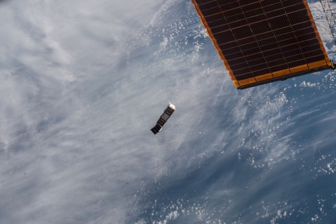 ESA’s GomX-3 CubeSat plus the smaller student-built AAUSat-5 after being deployed from the NanoRacks dispenser on Japan’s Kibo module of the International Space Station on 5 October. They entered space together but a spring system pushed them away from each other. By the end of the week they were orbiting upwards of 100 km apart. – Illustration issued on 16 October at 1222. ©ESA/NASA
ESA’s first technology-testing CubeSat, released in week commencing 4 October from the International Space Station, was said to be in good health and set to start work on its six-month mission, as reported on 16 October.
Despite its small size of 10x10x30 cm, the nanosatellite precisely controls its orientation by spinning miniaturised ‘reaction wheels’ at varying speeds. This precision is an important factor in the effectiveness of the mission’s technology testing payloads. One task will see GomX-3 pointing upwards to detect radio signals from telecom satellites in geostationary orbit in order to assess their overall transmission efficiency.
The processing software can be changed in flight, allowing the receiver to be reconfigured and used in extremely flexible ways, of wider interest for future
ESA missions.
Transas VTMS for port of Ajaccio
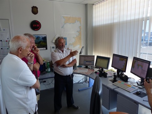
It was announced by Transas Marine Ltd in week ending 17 October that the port of Ajaccio, the main commercial port in the south of Corsica, is equipped now with the latest generation maritime Vessel Traffic Surveillance system. This project was implemented in partnership between territorial and state authorities of Corsica.
Within the project Transas delivered and installed its Navi-Monitor surveillance solution (illustrated) to monitor and manage the vessel traffic within the port in real-time mode. The Harbour Master’s office represents the heart of the system. The operator display units installed ensure the operational marine traffic picture is available in real-time and is based on the accurate data transmitted from several high-performant sensors including radar, antennas and VHF radio, AIS base station and weather station.
New helicopter for Great
Britain and Ireland
lighthouse contract

On 7 October helicopter operator PDG took ownership of a new EC135 helicopter with call sign G-GLAA. This helicopter has been purchased specifically to support the tri-General Lighthouse Authorities (GLA) helicopter services contract.
Handover of the machine was carried out during the Helitech exhibition at the London ExCel Centre. For the three GLAs this is a significant step towards the commencement of the new contract on 1 December 2015. The helicopter will carry out transport and utility operations including personnel transfers and logistics missions between operating bases, lighthouses and support vessels at sea.
UK ATS and Terma wind
turbine mitigation radar
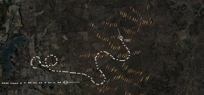 Wind turbines can cause interference to the radar signals that air traffic controllers use to direct aircraft. Turbine blades can appear as clutter on radar screens and be mistaken for aircraft.
It was announced from Aarhus, Denmark, on 7 October that Terma’s SCANTER 4002 radar system forms part of a turnkey surveillance solution to mitigate the impact of the 19 turbine 50MW onshore Frodsham Wind Farm Ltd., owned by Peel Energy and Belltown Power, on the radar systems at both Chester Hawarden and Liverpool John Lennon airports. The equipment will be delivered into service in February 2016, it is understood. The airports are facing the Irish Sea on Britain’s mid-west coast.
This pdf introduces earlier wind turbine radar trials.
Transas maritime training
in the Philippines
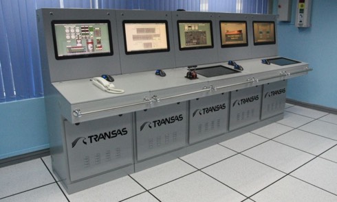
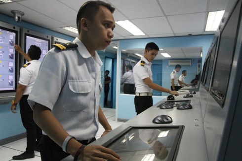
The rapid growth and development of the Philippine maritime training market caused a dramatic increase in demand for state-of-the-art simulation systems compliant with the latest MARINA and Commission on Higher Education (CHED) training requirements. This was stated in news from Transas Marine Limited on 1 October.
In order to enhance its range of services offered to the MET organisations in the Philippines, Transas has partnered with Philippine Lifesaving Equipment Inc., a local company with vast experience in the maritime market. Together, the companies are providing training for the Philippine market compliant with all international, as well as local, standards set by the Maritime Industry Authority of the Philippines (MARINA).
The Navigator – Nº 10
The Navigator, the aim of which is to inspire professionalism in marine navigators, is produced by The Nautical Institute in association with the Royal Institute of Navigation and appears every four months, that is February, June and October.
It is available in print form and may be downloaded in high resolution (4.39MB) and low resolution (855KB) pdf versions from the Nautical Institute’s website
exactEarth launches advanced equatorial AIS satellite
 This is a record of global shipping density and shows traffic from one typical month and highlights the busy tropical shipping regions for which exactEarth’s new equatorial satellite will provide expanded and detailed coverage. – Reproduced by kind permission of exactEarth©
It was announced from Cambridge, Ontario, Canada on 28 September that exactEarth Ltd., a leading provider of satellite AIS data services, reported the successful launch of an advanced AIS satellite, known as exactView-9 (EV9), thereby expanding its exactView™ global vessel monitoring constellation to eight in-orbit satellites.
This spacecraft was built by the University of Toronto Institute for Aerospace Studies Space Flight Laboratory and launched from the Satish Dhawan Space Centre in Sriharikota in India on 28 September aboard the Indian Space Research Organizations (ISRO) PSLV-C30 rocket.
Complementing the existing polar orbiting satellites of the exactEarth constellation, EV9 orbits around the equator every 97 minutes providing expanded and detailed coverage to the busy tropical shipping regions of the world.
Russian icebreaker innovation NEVA 2015
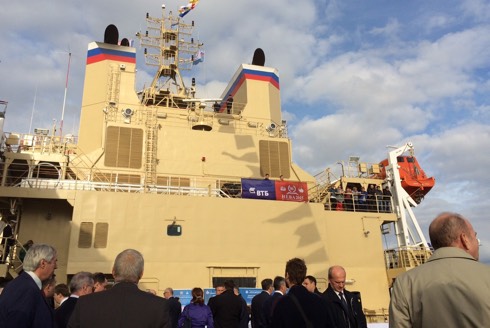
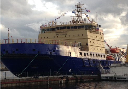
A spectacular ceremony (pictured) was held on the lead vessel of the icebreaker project 21900M in St. Petersburg on 23 September, forming part of the NEVA 2015 Programme. Guests and dignitaries came together to witness the official
flag-raising ceremony on board the icebreaker Vladivostok, seen here, and to celebrate all those involved in the project.
The diesel-powered icebreaker 21900M project, a modification of project 21900, was laid down at the Vyborg Shipyard in October 2012. Vladivstok is
the lead vessel in the series of three diesel-electric icebreakers built for FSUE
Rosmorport and classed by the Russian Maritime Register of Shipping.
Vladivostok is able to overcome ice thickness of up to 1.5 metres and her main purpose is the independent escort of large capacity vessels, towing,
extinguishing fires on floating facilities and other structures, providing
assistance to ships in distress, and the transport of cargo.
Resilient PNT Forum IV


![]()
The International Association of Institutes of Navigation (IAIN) holds its Congress in Prague from 20-24 October 2015. The fourth Forum on Resilient Positioning, Navigation and Timing (PNT) will be held from 1600-1800 on 20 October 2015, immediately preceding the Conference in the same venue.
This follows three very successful events at ENC 2014 in Rotterdam, at ION ITM 2015 at Dana Point California and at ENC 2015 in Bordeaux. The motivation for these events is the increasing reliance on Global Navigation Satellite Systems in all transport sectors, for timing and other essential infrastructure throughout the World.
Note: there is no charge for this event, those wishing to attend are invited to register their interest with the organisers, nick-dot-ward-at-gla-hyphen-rrnav-dot-org
The day’s programme can be found here.

