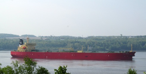
AIS vulnerability
![]()
Research results have been published recently showing that AIS information provided on internet sites can be spoofed – that is false information can be presented, including the names and other details of vessels, their position and status.
These vulnerabilities have, in fact, been well-known since the early days of AIS and maritime administrations do not rely on these internet sites for the services they provide. However, this publicity may result in organisations in the international navigation community facing questions. The following briefing note may assist in answering those questions.
EU r&d project to demonstrate unique transport security model
 ARENA was specifically developed to enable the automatic detection and recognition of threats against trucks…
A practical demonstration of the ARENA R&D project, part funded by the EU, will be delivered at Sagem’s premises in Massy, Paris, on 16th April 2014.
 …trains…
ARENA (Architecture for Recognition of thrEats to mobile assets using Networks of Affordable sensors) was specifically developed to enable the automatic detection and recognition of threats against mobile critical assets such as trucks, trains and ships, as well as off shore platforms. ARENA uses multisensory data analysis and will be showcased by the project team using a truck.
 …offshore platforms…
Specific objectives of the ARENA project include the demonstration of robust threat detection for the land scenario and an integrated, scalable and easy to deploy monitoring system. These two objectives will be met at the event.
 …and shipping using multisensory data analysis and where the surveillance model robustly and autonomously detects threats to these assets.
ICAO launches new runway safety iKit
![]()
On 5th March ICAO announced from its HQ in Montreal that in line with its ongoing co-operative efforts to resolve what remains the number one priority for global aviation safety experts, it has released a new Runway Safety Implementation Kit (iKit), developed in collaboration with a number of international organizations including IATA, IFALPA, EASA and EUROCONTROL.
ICAO’s Dr Assad Kotaite dies at age 89
![]()
Universally recognized as one of the most prominent and respected figures in the world of civil aviation, Council President Emeritus of the International Civil Aviation Organization (ICAO), Dr. Assad Kotaite, died on 27th February at the age of 89.
A respected leader and visionary who devoted his life to the safe and orderly growth of international civil aviation throughout the world, Kotaite’s remarkable career mirrored the evolution of ICAO for over half a century. He was also deeply instrumental in promoting the critical role of air transport as a driver of economic, social and cultural development worldwide.

NTSB offers assistance to Malaysia
![]() On 8th March the US National Transportation Safety Board NTSB reported that it had a team of investigators en route to Asia to be ready to assist with the investigation of that day’s Malaysia Airlines Flight 370 event. The Boeing 777 went missing on a flight from Kuala Lumpur to Beijing.
On 8th March the US National Transportation Safety Board NTSB reported that it had a team of investigators en route to Asia to be ready to assist with the investigation of that day’s Malaysia Airlines Flight 370 event. The Boeing 777 went missing on a flight from Kuala Lumpur to Beijing.
Signals from a speeding satellite
Soaring high above Earth as they speed through space, satellites are difficult
targets to track, said ESA in a paper issued on 7th March. Now a new approach
developed in Europe is helping ground stations to acquire signals faster and
more accurately than ever before.
Says Magdalena Martinez de Mendijur, a systems engineer at ESA’s Operations Centre in Germany: “If the antenna is not pointed perfectly, or if the satellite zips by out of its field of view before acquisition, the signal could be missed altogether.”
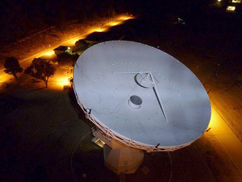 Upgraded station in Spain
That’s where SARAS – a Spanish acronym for ‘Fast Acquisition of Satellites and Launchers’ – is making a huge difference. The system mounts a circular array of eight small radio-frequency sensors around the rim of an existing dish antenna.
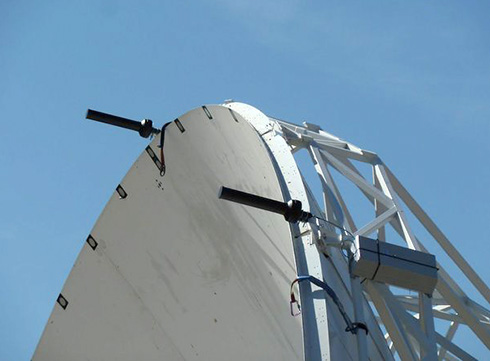 New antenna array
Sealite news
In February 2014 marine aids to navigation manufacturer Sealite United Kingdom Ltd relocated to a larger facility at 11 Pinbush Road, Lowestoft, Suffolk.
 New larger facility for Sealite in the UK
Towards the end of February Sealite reported that a major European port had selected the company’s high-precision LED port entry light, fitted with GSM for remote monitoring.
 Sealite’s LED port entry light (PEL)
In recent weeks Sealite announced that its Nautilus ocean buoy with a three to five nautical mile range with marine lantern had been established at the Scroby Sands Wind Farm.
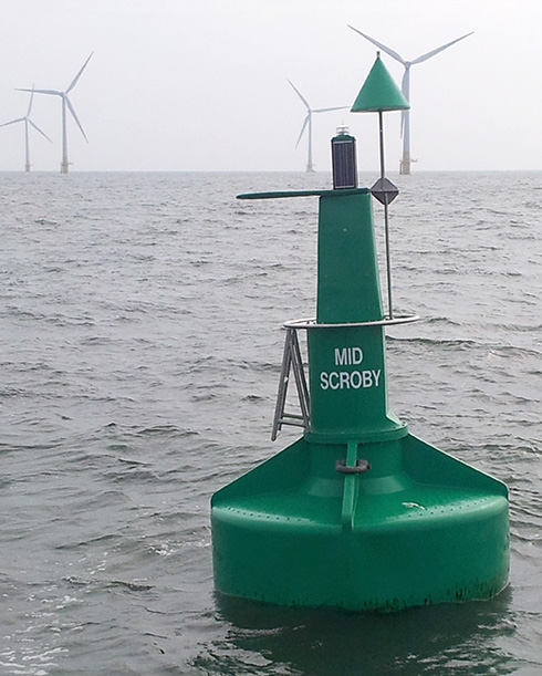 A Sealite Nautilus ocean buoy with 3 to 5 NM marine lantern was recently established at the Scroby Sands Wind Farm, east coast of England
ESA’s Sentinel-1A radar satellite
 Sentinel-1 arrival at Europe’s Spaceport in French Guiana
The European Space Agency reported on 25th February that its Sentinel-1A radar satellite had arrived at Europe’s Spaceport in French Guiana to be prepared over the coming weeks for launch on 3rd April. Its launch will mark a new shift in Earth observation, focusing on operational missions to support users for decades to come.
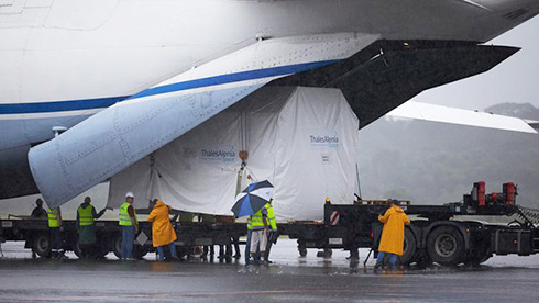 Sentinel-1 being unloaded
This first mission carries an advanced radar sensor to image Earth’s surface
through cloud and rain and regardless of whether it is day or night.
 Sentinel-1 will be carried by the Soyuz rocket into space
e-Navigation architecture workshop
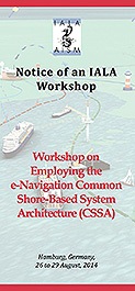
IALA with the German Federal Waterways and Shipping Administration is hosting a workshop on employing the e-Navigation Common Shore-Based System Architecture (CSSA) to be held in Hamburg from 26th to 29th August 2014.
In recent years IALA has been heavily engaged in developing the IMO e-Navigation concept including aspects of e-Navigation architecture. This workshop will cover subjects related to the CSSA and its individual services including implementation options, cost, quality, organisation for life cycle management and Maritime Service Portfolios (MSPs).
NATO’s submarine capacities in Dynamic Mongoose-14
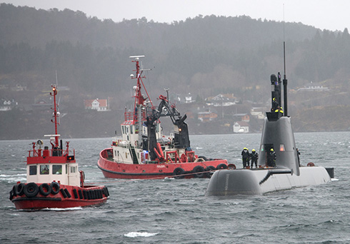 Portuguese submarine berthing in Bergen Naval Base
 Norwegian submarine in the fjord near Bergen
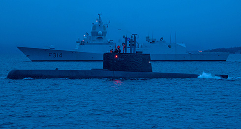
![]() It was reported from Bergen, Norway, on 21st February that NATO’s submarine warfare Exercise DYNAMIC MONGOOSE 2014 (DMON 14) had been concluded that day off the coast of Norway, as the ships, submarines, aircraft and personnel from eight participating Allied nations wrapped up the simulations and began to take stock of the lessons the exercise provided for future operations.
It was reported from Bergen, Norway, on 21st February that NATO’s submarine warfare Exercise DYNAMIC MONGOOSE 2014 (DMON 14) had been concluded that day off the coast of Norway, as the ships, submarines, aircraft and personnel from eight participating Allied nations wrapped up the simulations and began to take stock of the lessons the exercise provided for future operations.
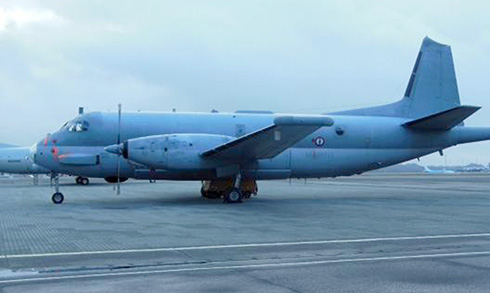 French Atlanta 2 ASW patrol aircraft on the tarmac at Sola Airport, Stavanger
Rough weather provided a challenging environment for the participants, who were given the opportunity to train for a variety of high end maritime warfighting skills. During the exercise, participating surface ships also had the opportunity to conduct difficult manoeuvres involved in replenishment-at-sea (RAS) training.
 Norwegian submarine and HNoMS Thor Heyerdahl in the fjord near Bergen
 SNMG1 Flagship HNoMS Thor Heyerdahl (F314) followed by FGS Hamburg
(F220), FGS Augsberg (F213) and FGS Mecklenberg-Vorpommern (F218)
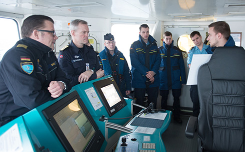 Captain Steinweller (CO FGS Magdeburg) at left, and Commodore Stensønes
(COM SNMG1) attending a manoeuvre briefing by the Navigating Officer
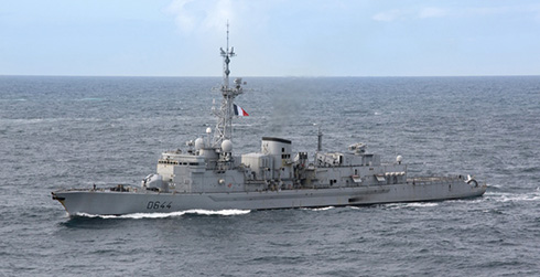 FS Primaguet
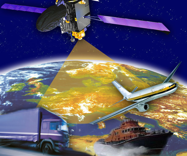
Galileo aviation augmentation
Plans to harness Galileo and other satellite navigation systems for next generation satellite augmentation systems for aviation and other high performance uses took a significant step forward at the latest gathering of worldwide operators and experts, reported by the European Space Agency in mid-February.
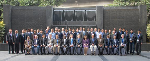 Working group participants
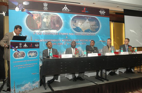 Opening of the Working Group, New Delhi
Satellite augmentation systems combine additional ground stations and satellite transponders to sharpen navigation accuracy and reliability across given geographical regions – based on the US GPS for now, but with plans to move to a multi-constellation design additionally employing Europe’s Galileo, China’s Compass and Russia’s Glonass systems in the post-2020 era.
 EGNOS sharpens GPS accuracy over Europe
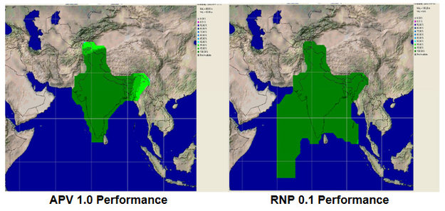 GAGAN service coverage, India
Radar on Chesapeake Bay
On 19th February Kelvin Hughes announced that it has supplied SharpEye™ Solid State X Band surveillance technology to the Maryland Natural Resources Police (MNRP) to enhance their enforcement network in protected areas.
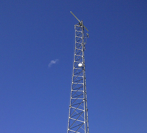 The Chesapeake Bay antenna
This network monitors illegal activity across 3,100 miles of Maryland coastland, including oyster sanctuary waters in Chesapeake Bay. Such solid state radars are able to detect small, low-radar cross section targets such as boats used by poachers.
 screen shot
 The Kelvin Highes radio transceive
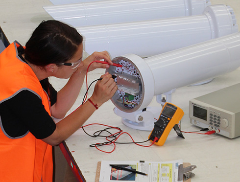
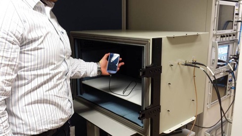
Galileo for the mass market
 Satellite navigation constellation
With the first Galileo services set to begin this year, the European Space Agency (ESA) is working directly with European manufacturers of mass-market satellite navigation chips and receivers to ensure that their products are Galileo-ready.
 Hybrid localisation solution rack
Explained Riccardo de Gaudenzi, head of ESA’s Radio Frequency Systems, Payload and Technology Division, “Our objective is to make sure, ahead of the EU’s declaration of early Galileo services that mass-market devices are ready and able to make use of them. In co-ordination with the European GNSS Agency, we put out an open call to satellite navigation manufacturers offering testing with our laboratory facilities. We have gone on to work with five massmarket chipset makers and a comparable number of professional receiver manufacturers.”
 Octobox
 ESA Lab’s Telecommunications and Navigation Testbed vehicle
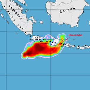
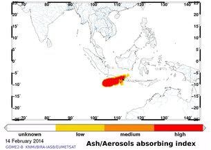
Indonesia’s Kelud erupts
Kelud volcano on Indonesia’s Java island erupted late on the night of 14th February. While disaster-management authorities are busy on the ground, satellites are tracking the major cloud of ash and sulphur dioxide as it spreads in the atmosphere. “The ash has reached high altitudes where commercial aircraft
fly and is a significant hazard to aviation,” said Fred Prata from the Norwegian
Institute for Air Research. Airports across Java have closed, and multiple flights have been cancelled throughout the region.
ENC GNSS early bird registration
![]()
The Netherlands Institute of Navigation (NIN) has announced the annual European Navigation Conference (ENC), will be held from 15th to 17th April 2014 in the World Trade Center, Rotterdam under the auspices of the European Group of Institutes of Navigation (EUGIN). This conference will focus on technology, innovation and the transfer to business applications in the PNT sector.
An Early Bird rate available is available until 15th February. Participants who register for the conference before 15th February will be offered a discount on their registration fee. The regular fee is € 895. Early Birds will pay € 795.
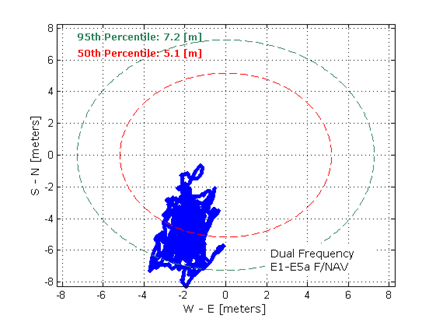
Galileo in-orbit validation
The in-orbit validation of Galileo has been achieved, it was reported by ESA on 10th February such that Europe now has the operational nucleus of its own satellite navigation constellation in place – the world’s first civil-owned and operated satnav system.
In 2011 and 2012 the first four satellites were launched into orbit. Four is the minimum number needed to perform navigation fixes. In the following year, these satellites were combined with a growing global ground infrastructure to allow the project to undergo its crucial In-Orbit Validation phase: IOV.

Galileo’s observed dual-frequency positioning accuracy is an average 8m horizontally and 9m vertically, 95% of the time. Its average timing accuracy is 10 billionths of a second – and its performance is set to sharpen as more satellites are launched and ground stations come on line.
Terma in Belarus

It was announced from Lystrup, Denmark at the end of January that Terma had been contracted by Thales Air Systems S.A.S. to deliver and install a SCANTER 5502 Surface Movement Radar (SMR) system to Minsk-2 International Airport in Belarus. Delivery is part of the Belarussian air navigation services company BELAERONAVIGATSIA SOE’s investment in airports before the ice hockey World Cup which begins in May.
ABS publishes advisory for navigating Northern Sea Route
ABS, a leading provider of global maritime classification services, with Headquarters in Houston, on 29th January released its Navigating the Northern Sea Route Advisory to support shipowners and operators intending to transit the increasingly popular commercial shipping routes through the Arctic seas.
![]() This comprehensive advisory, which was developed with assistance from Russia’s Central Marine Research and Design Institute, provides shipowners with the information they need to apply for permits and to identify the possible technical and operational risks that could arise when trading in some of the world’s most challenging commercial shipping environments.
This comprehensive advisory, which was developed with assistance from Russia’s Central Marine Research and Design Institute, provides shipowners with the information they need to apply for permits and to identify the possible technical and operational risks that could arise when trading in some of the world’s most challenging commercial shipping environments.
 ABS classed vessels able to navigate the Northern Sea Route
Trading through the NSR has the potential to reduce the typical transit times between Japan and Rotterdam by as much as 3,400 miles – or ten days – compared to the traditional route via the Suez Canal.
2013 ICAO Air Services Negotiation conference
![]()
Shortly before Christmas the sixth ICAO Air Services Negotiation Conference (ICAN2013) wound up on a record note in Durban, South Africa, with 73 States/territories using the unique ICAN one-stop negotiation facility to conclude over 500 new air services and open skies agreements.
Private operator ACR takes over more towers

The deregulation of air traffic services (ATS) at Swedish airports has taken off well and since the end of 2013 the private Swedish company ACR Aviation Capacity Resources is now operating the control towers at nine of the country’s 36 airports. ACR more than doubled their business when the company took over the towers at the airports in Kalmar, Jönköping, Norrköping, Karlstad and Skellefteå on 1st January 2014.

2013 safest year
![]()
ICAO announced on 17th January that preliminary data confirmed that 2013 was the safest year ever recorded in terms of fatalities for scheduled international air transport operations.
Although the number of fatal accidents involving scheduled commercial operations remained steady at nine during 2013, fatalities themselves were down a significant 53.5% from 2012, dropping to only 173 compared to 372 the previous year. Using 2010 as a baseline, fatalities have fallen by a huge 76% and 2013 represents the third consecutive year in which air transport fatalities have continued to decrease.
ICAO welcomes new TIACA report
![]()
It was announced by ICAO from Montreal on 22nd January that a task force led by the International Air Cargo Association (TIACA), with active support from the International Air Transport Association (IATA) and the International Federation of Freight Forwarders Associations (FIATA), reported the completion of a two-year
project on educational needs for the next-generation of managers for the worldwide air cargo industry.
Resilient PNT Forum
The Netherlands Institute of Navigation (NIN) is hosting the annual European Navigation Conference (ENC-GNSS 2014), to be held from 15th to 17th April 2014 in the World Trade Center, Rotterdam under the auspices of the European Group of Institutes of Navigation (EUGIN). The conference will focus on technology, innovation and the transfer to business applications in the PNT sector.
The annual market for global navigation satellite products and services is currently valued at € 124 billion and is expected to grow over the next decade, leading to an estimated market size of € 244 billion in 2020. With the Galileo system having 18 satellites by the end of 2014, many new applications will be developed in combination with other GNSS systems and other Positioning, Navigation and Timing (PNT) sensors.
The programme can be found here.
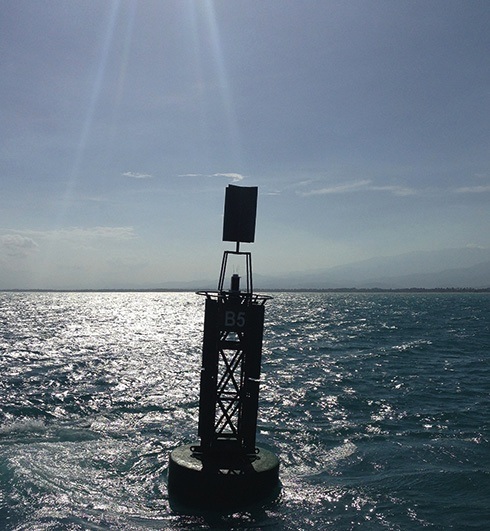
Aids to navigation, La Guajira, Colombia
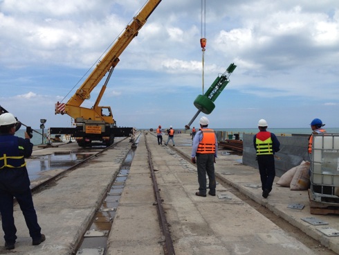
Almarin, a Spanish manufacturer of marine aids to navigation, reports that it has completed the design and turnkey supply of aids to navigation for Puerto Brisa, La Guajira, Colombia. The company provided 14 buoys: twelve lateral marks, one safe water mark and one special mark. All buoys, from its ‘Guía’ range, were provided with self-contained lights equipped with satellite monitoring.
India’s satellite-based augmentation system certified

According to the RIN website India’s Satellite Based Augmentation System has become the fourth such system to offer improved navigation.
On 30th December, the Indian Directorate General of Civil Aviation (DGCA) provisionally certified the country’s Satellite Based Augmentation System (SBAS) programme, the GPS Aided Geo Augmented Navigation (GAGAN) system, to the ‘Required Navigation Performance, 0.1 Nautical Mile’ (RNP0.1) service level. This will enable SBAS-capable aircraft to use GAGAN signals in space for en-route navigation and non-precision approaches – those without vertical guidance – in Indian air space.
GAGAN will bridge the gap between the EU’s EGNOS and Japan’s MSAS coverage areas, offering a huge area of seamless navigation to the aviation industry.