Titanic’s legacy reaches space

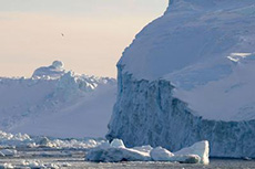
World’s busiest ice-covered sea – image courtesy of ESA
A century ago, RMS Titanic struck an iceberg while crossing the North Atlantic and sank at the cost of over 1500 passengers and crew. Today, thousands of vessels cross the same iceberg-ridden path with no loss of life – and satellites are helping.

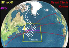
The International Ice Patrol area of operation. This view of the North Atlantic and surrounding continents displays the International Ice Patrol’s Area Of Operations (AOR) in yellow from 40°N to 50°N, and 39°W to 57°W. The 48°N latitude line is drawn in purple within the Ice Patrol AOR. The transatlantic shipping lanes from Europe to North America are in red. Typical iceberg paths and distribution within the AOR are represented by numerous white triangles along the 200 m bathymetry from Greenland to the Grand Banks of Newfoundland. The position of the 1912 Titanic sinking is represented by a white asterisk at the tail of Grand Banks near the bottom of the Ice Patrol AOR. – image courtesy of IIP
