African land cover as seen by satellite

African land cover as seen by satellite – Id335300 -©ESA/ATG Medialab. Copyright contains modified Copernicus Sentinel data (2015-2016), processed by Land Cover CCI, ESA.

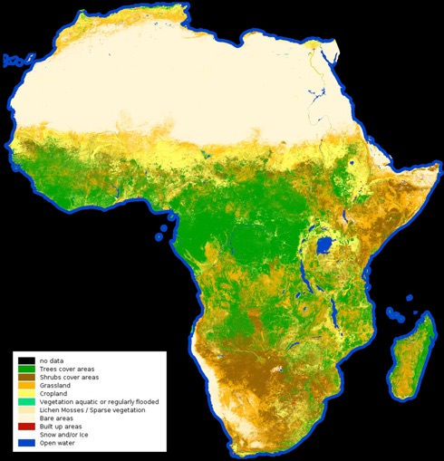
From the barren Sahara to lush jungles, the first high-resolution map classifying land cover types on the entire African continent has been released by the European Space Agency (ESA). This map was created using a year’s worth of data from the Sentinel-2A satellite and as can be seen it shows Africa’s diverse landscapes from grasslands to croplands, water bodies to deserts.

Land-cover mapping breaks down the different types of material on the Earth’s surface. This information is important for understanding changes in land use, modelling climate change extent and impacts, conserving biodiversity and managing natural resources.

The Sentinel-2 satellite over Italy and the N Mediterranean – photo ESA©

The map released early in October comprises 180,000 Sentinel-2A images representing 90 terabytes of data captured between December 2015 and December 2016. Considering the size of the map – about six gigabytes – a web interface was developed to visualise the data.

Où acheter du stromectol générique Where to buy generic stromectol Dónde comprar stromectol genérico Wo kann man generisches Stromectol kaufen? Dove acquistare stromectol generico Πού να αγοράσετε γενόσημο stromectol Onde comprar estromectol genérico ストロメクトールジェネリックはどこで買える? Kde koupit generický stromectol Hvor kan man købe generisk stromectol Waar kunt u generieke stromectol kopen? Hol vásárolhat általános stromectolt Di mana untuk membeli stromectol generik حيث لشراء ستروميكتول عام Hvor kan man kjøpe generisk stromectol Gdzie kupić generyczny stromectol Kde kúpiť generický stromectol Var kan man köpa generisk stromectol Mistä ostaa geneeristä stromectolia De unde să cumpărați stromectol generic